 U-2307B: 29th Avenue NE Improvements - Hickory
U-2307B: 29th Avenue NE Improvements - Hickory
NCDOT is proposing to improve the corridor between N.C. 127 and Springs Road along 29th Avenue NE/24th Street NE, in Hickory.
Interactive Project Study Area Map
This map is for reference only and is a representation of the general project area.
Project Highlights
The project was first introduced, and approved, in the early 1990s.
In 1992, a typical section was approved for the project corridor that would widen the roadway to include curb and gutter, a continuous center-turn lane, and two lanes of travel in each direction. No bicycle or pedestrian accommodations were included in the design. This typical section no longer meets current NCDOT design standards.
The southern half (McDonald Parkway) was constructed in the early 2000s. Current project study updates were initiated in Spring 2018 but were suspended in Summer 2019 and again in 2020 due to funding constraints and impacts from COVID-19.
NCDOT, working with the City of Hickory and the Greater Hickory Metropolitan Planning Organization (MPO), restarted planning and design work for this project in Summer 2023.
NCDOT updated the project corridor data, including current traffic, and changes in land use that could influence future traffic conditions.
Preferred Alternative
The Preferred Alternative updates the project corridor to current NCDOT design standards. The 29th Avenue NE /24th Street NE corridor will be widened from two lanes to multi-lanes, includes curb and gutter, Reduced Conflict Intersections (RCI's), 11-foot travel lanes, a 23-foot raised grass median, a 5-foot sidewalk along the north side of the corridor, and a 10-foot multi-use path along the south side of the corridor.
Public Meeting Maps
The following maps were shown at a Public Meeting held on November 19, 2024.
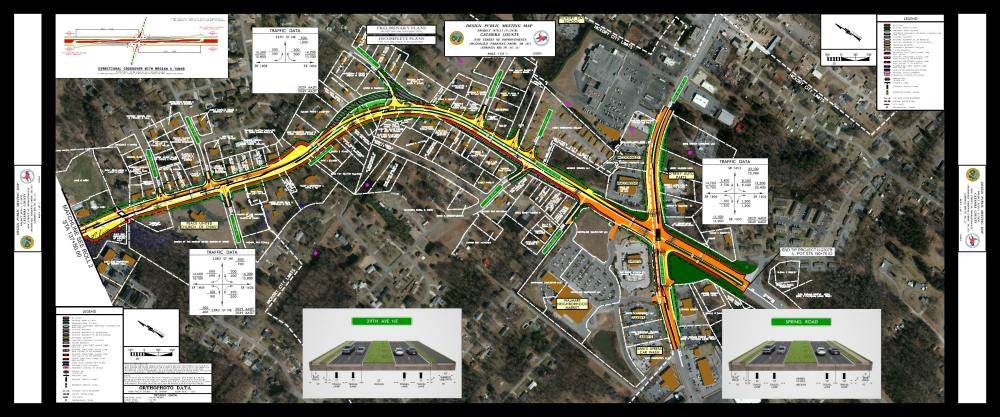
Map 1 - Start of Project North Center Street to 8th Street Court N.E./Wynnshire Way

Map 2 - West of Falling Creek Road to 20th Avenue Drive N.E/20th Street Lane N.E.
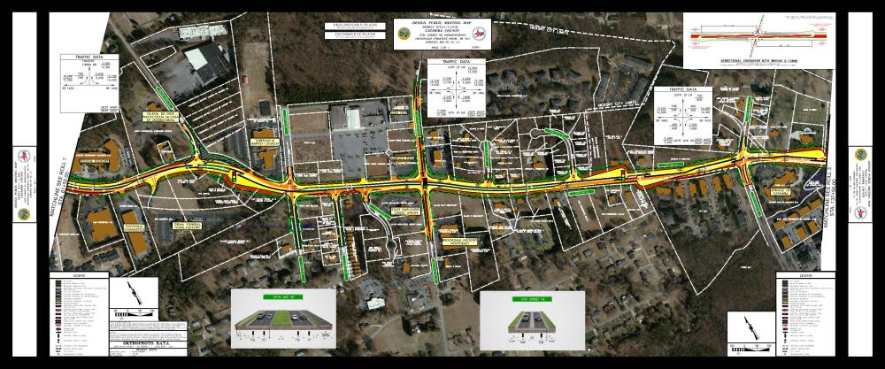
Map 3 - 22nd Street N.E. to Spring Road N.E. (End of Project)
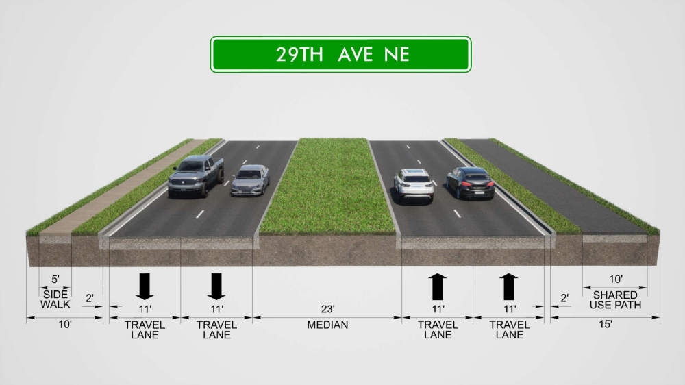
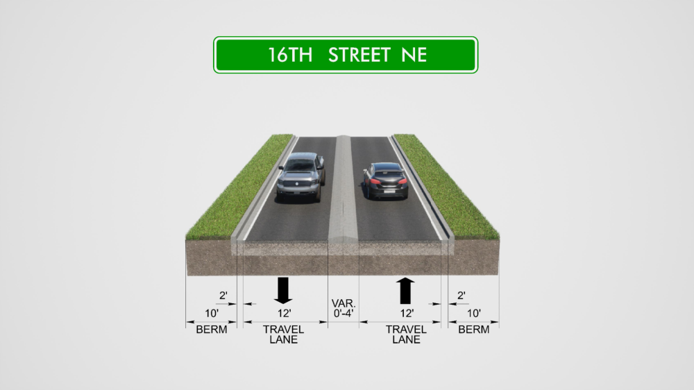
Proposed Typical Sections
_______________________________________________________________
The proposed typical section along 29th Avenue NE / 24th Street NE includes four 11-foot travel lanes, a 23-foot raised median,
a 5-foot sidewalk along the north side of the corridor and a 10-foot multi-use path along the south side of the corridor.
_______________________________________________________________
The proposed typical section along 16th Street NE includes two 12-foot travel lanes and a raised concrete median
_______________________________________________________________
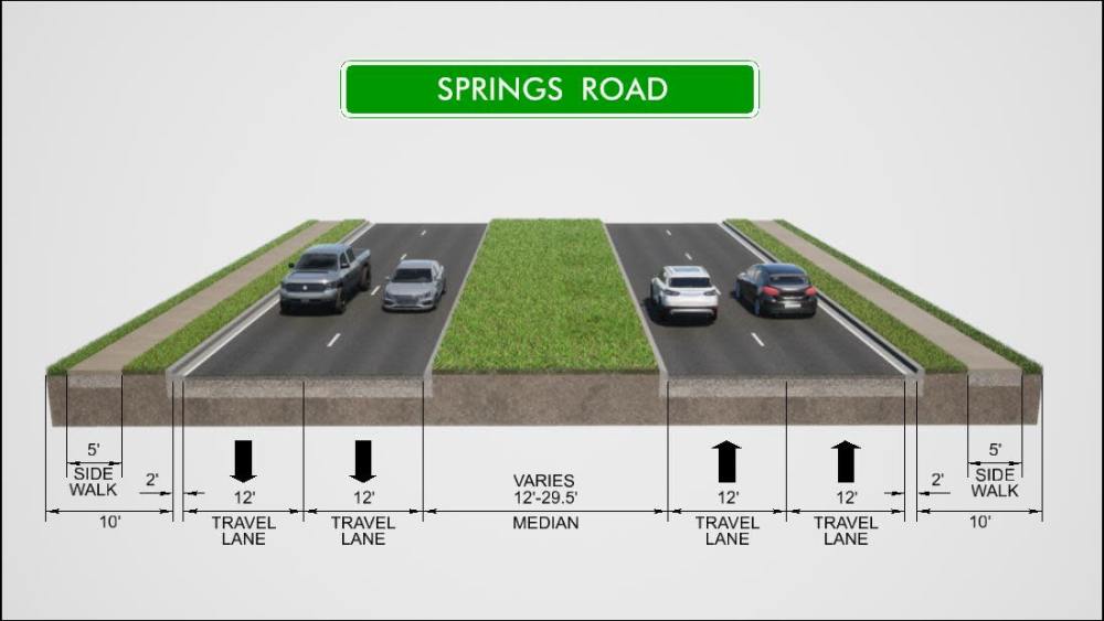
The proposed typical section along Springs Road includes four 12-foot travel lanes, a 12 to 29.5 foot raised median,
a 5-foot sidewalk along the north and south side of the corridor.
_______________________________________________________________
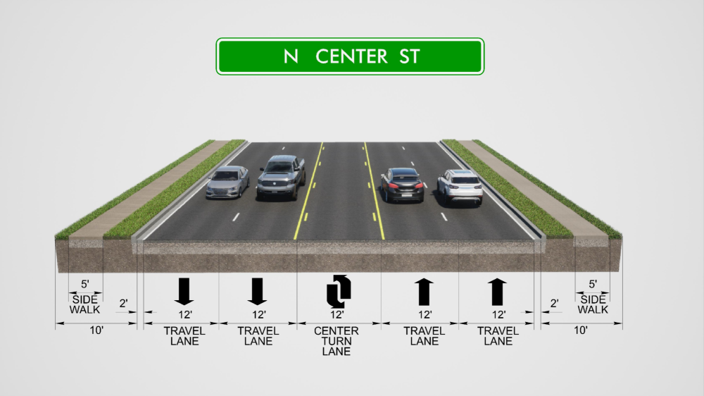
The proposed typical section along North Center Street includes four 12-foot travel lanes, a center turn lane,
and a 5-foot sidewalk along the north and south side of the corridor.
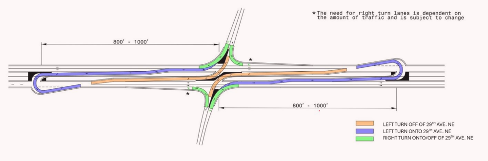
Reduced Conflict Intersections
A Reduced Conflict Intersection – sometimes referred to as a superstreet, a synchronized street, or a median U-turn is a general term used to describe several types of designs that can be used to improve safety and traffic flow on a highway by cutting more than half of the potential locations, or conflict points, where drivers and pedestrians can collide.
The most common type of Reduced Conflict Intersection design eliminates left turns from side roads onto busy main roads. Raised medians direct traffic from the side road into turning right. When there is a safe opening in traffic, drivers enter the flow of traffic on the main route. To go the other direction, or cross the highway, drivers pull into a dedicated lane – typically less than 1,000 feet away – and make a U-turn. There might be a traffic signal at this location.
With a Reduced Conflict Intersection, drivers from the side street only have to be concerned with one direction of traffic on the highway at a time and do not need to wait for a gap in both directions to cross a major road.
Watch a video about how Reduced Conflict Intersections (RCI's) work
Project Funding:
Milestone | Estimated Amount* |
Right-of-Way Acquisition | $ 112.6 million |
Utility Relocation | $ 15.7 million |
Construction | $ 64.7 million |
Total Cost | $ 193 million |
* Estimated costs are preliminary and subject to change
Project Timeline:
Milestone | Date* |
Environmental Document Completed | Summer 2025 |
Right-of-Way Acquisition Begins | Fall 2026 |
Construction Begins | Summer 2029 |
* Future dates are preliminary and subject to change
Project Comments:
NCDOT accepts comments throughout all phases of project development.
All comments will be taken into consideration, and carry equal weight, regardless of submittal method.
Comments for consideration during the current phase of project development
were to be submitted by December 31, 2024.
The public is encouraged to leave comments using this webpage, by email, or phone or USPS mail to the project managers listed below:
Email: 29th-Avenue-NE@PublicInput.com
Phone Number: 984-205-6615 and enter project code 4277 to leave a message
Project Contact Information
Nathan Adima, PE
NCDOT
NCDOT Project Manager
1582 Mail Service Center
Raleigh, NC 27699-1582
Project Contact Information
Bryce Reid, PE
Dewberry
Consultant Project Manager
2610 Wycliff Road, Ste 410
Raleigh, NC 27607-3073
Title VI Feedback
To ensure we’re hearing from a broad set of voices, would you be willing to share (completely anonymously) some information about yourself?
If so, please click here: https://publicinput.com/NCDOT-Title-VI-Form
RESOURCES FOR PROPERTY OWNERS
Although the N.C. Department of Transportation works to minimize the number of homes and businesses displaced by a road
project, it is inevitable, in many cases, that a certain amount of private property is needed. The following information explains right
of way acquisition and answers questions about the process.
Right-of-Way Brochure Single Page Layout Folleto del Proceso de Adquisición de Bienes Raíces
Right-of-Way Frequently Asked Questions
Right of Way Acquisition Process Videos
Page last updated: June 15 2026
ADA Compliance Checked