 BR-0177: Bridge on Old U.S. 421 over Yadkin River
BR-0177: Bridge on Old U.S. 421 over Yadkin River
NCDOT proposes to replace the bridge on Old U.S. 421 over the Yadkin River, west of Pfafftown in Yadkin and Forsyth Counties.
Step 1
A summary of the comments and responses will be posted after the March 21, 2025 comment period ends.
The summary to comments and responses from November 13, 2024 can be viewed here.
Interactive Study Area Map
Project Overview
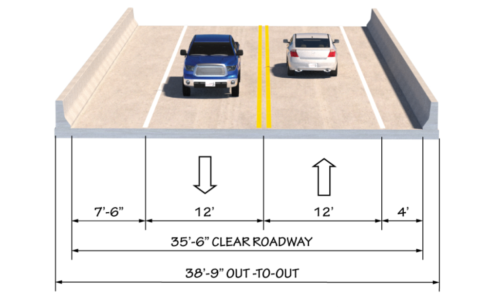
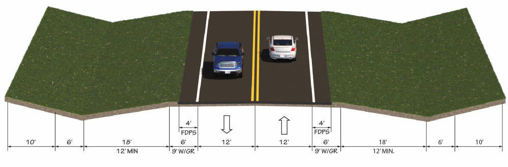
The project proposes to replace the Bridge on Old U.S. 421 (S.R. 1605) over the Yadkin River west of Pfafftown in Yadkin and Forsyth Counties. A new bridge would be constructed adjacent to the existing bridge and traffic would be maintained on the existing bridge during construction. The proposed bridge is approximately 1,020 feet long, and contains two 12-foot lanes with a 4-foot shoulder on one side and a 7.5-foot shoulder on the other. The bridge approaches would include up to 9-foot shoulders, of which 4 feet is paved.
Minor additional right of way will be required and temporary easements would be utilized during construction.
The October 2020 Winston Salem Urban Area Metropolitan Planning Organization Comprehensive Transportation Plan (CTP) lists Old U.S. 421 as "needs modernization" with bike lanes along Old U.S. 421 and a multi-use path along the Yadkin River . The Northwest Piedmont Rural Planning Organization 2014 Yadkin County CTP recommends widening of Old U.S. 421 to two 12-foot lanes with paved shoulders from Unifi Industrial Road (S.R. 1765) to Forsyth County.
Two alternatives are being studied.
Alternative 1 is south (downstream) of the existing bridge.
Alternative 2 is north (upstream) of the existing bridge.
The alternative project maps alone with the alternative comparison table are shown below.
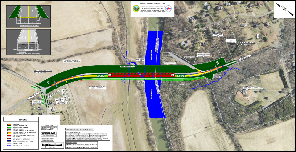
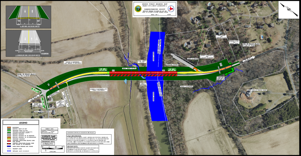
Comparison table between Alternative 1 and Alternative 2
Impacts* | ALTERNATIVE 1 | ALTERNATIVE 2 |
Location | South and downstream of existing bridge | North and upstream of existing bridge |
Cost | TBD | TBD |
Parcels affected | 3 (permanent Right-of-Way) | 2 (temporary easements) |
Length of project | 2,575' feet | 2,790' feet |
Length of bridge | 1,020' feet | 1,020' feet |
Park impacts (within NCDOT Right-of-Way) | Realign park entrance | - Realign park entrance - Lose ADA accessible sidewalk to picnic tables and to boat ramp |
Relocations | 0 | 0 |
Sight distance | - Improved for right turns out of park - Decreased for left turns out of park | - Improved for left turns out of park - Decreased for right turns out of park |
Farmland/Forest impacts | Yes | No |
*Impacts are based on preliminary plans and are subject to change.
Typical Sections
Bridge
Approaches to Bridge
Project Funding:
Activity | Estimated Costs* |
Right-of-Way Acquisition | $ 1.2 Million |
Construction | $ 16.8 Million |
Total Cost | TBD |
*Estimated costs are subject to change. Updated cost estimates will be provided soon.
Project Timeline:
Activity | Anticipated Date* |
Right-of-Way Acquisition Begins | November 2025 |
Construction Begins | January 2027 |
*Future dates subject to change
Project Comments:
NCDOT accepts comments throughout all phases of project development.
All comments will be taken into consideration, and carry equal weight, regardless of submittal method.
Comments for consideration during the current phase of project development
were to be submitted before March 21, 2025.
The public is encouraged to leave comments using this webpage, email, or phone number:
Email: Old-US-421-Yadkin-River@publicinput.com
Phone Number: 984-205-6615 and enter project code 6090
Project Contact Information
Khaled Alakhdar
Project Manager
NCDOT Project Management Unit
1582 Mail Service Center
Raleigh, NC 27699-1582
Project Contact Information
Liz Workman
Consultant Project Manager
Three Oaks Engineering
1730 Varsity Drive, Suite 140
Raleigh, NC 27606
Title VI Feedback
To ensure we’re hearing from a broad set of voices, would you be willing to share (completely anonymously) some information about yourself?
If so, please click here https://publicinput.com/NCDOT-Title-VI-Form
Resources for Property Owners
Although the N.C. Department of Transportation works to minimize the number of homes and businesses displaced by a road
project, it is inevitable, in many cases, that a certain amount of private property is needed. The following information explains right
of way acquisition and answers questions about the process.
Right-of-Way Brochure Single Page Layout Folleto del Proceso de Adquisición de Bienes Raíces
Right-of-Way Frequently Asked Questions
Right of Way Acquisition Process Videos
Page last updated: May 13, 2026
ADA Compliance Checked