 R-5963: South Chatham Park Way - Pittsboro
R-5963: South Chatham Park Way - Pittsboro
NCDOT is proposing to construct South Chatham Park Way in Chatham County.
Project Study Area
This map is for reference only and is a representation of the general project area and sections.
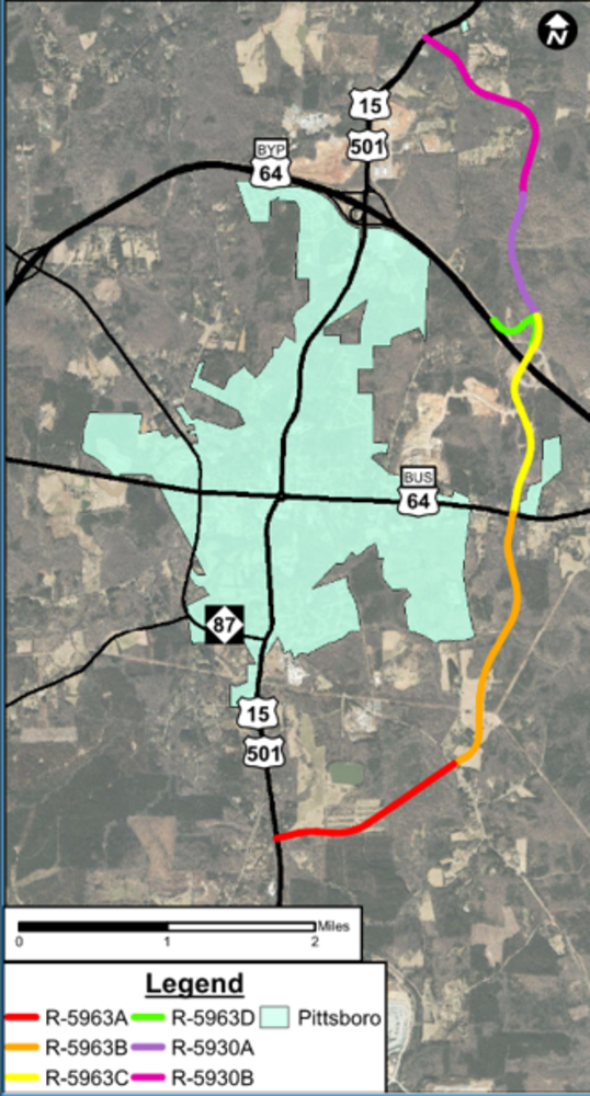
South Chatham Park Way
Project Overview Video
Project History
The alignment of Project R-5963 was initially studied as part of a feasibility study in 1994. Since then, similar alignments have been included in various local plans including the Chatham County 2017 Comprehensive Plan, Plan Chatham and the Pittsboro 2015 Comprehensive Transportation Plan with a revised northern terminus of U.S. 15-501.
A second feasibility study was completed in 2019 to evaluate a new road from U.S. 15-501 south of Pittsboro to U.S. 15-501 north of Pittsboro utilizing the existing section of Chatham Park Way between U.S. 64 Business and U.S. 64 Bypass. The route was funded as two separate projects: R-5930 (the northern section) and R-5963 (the southern section).
Project Description and Highlights
The proposed project, State Transportation Improvement Program (STIP) Project No. R-5963, begins at U.S. 15-501 south of Pittsboro and ends at U.S. 64 on the east side of Pittsboro. This project, also referred to as South Chatham Park Way, will build a 3.3-mile road on new location from U.S. 15-501 to U.S. 64 Business, and will widen the existing 1.1-mile roadway from U.S. 64 Business to U.S. 64. Together with the North Chatham Park Way (NCDOT Project R-5930), this project will complete an eastern loop around downtown Pittsboro. The project is intended to provide an alternate route for traffic traveling through downtown Pittsboro while continuing to support the economic development of the region. It will increase mobility options for drivers, bicyclists, and pedestrians.
The project has been divided into 3 phases for construction.
Phase A: U.S. 15-501 south of Pittsboro to U.S. 64 Business
Phase C: Widening of existing, Chatham Park Way from U.S. 64 Business to just north of U.S. 64
Phase D: Construction of a new westbound on-ramp from Chatham Park Way to U.S. 64 and realignment of Suttles Road to a new intersection with Chatham Park Way
The preferred alternative:
- Together with North Chatham Park Way (NCDOT Project R-5930), this project will complete an eastern loop around downtown Pittsboro.
- Will provide an alternate route for traffic traveling through downtown Pittsboro.
- May continue to support the economic development of the region.
- Will increase mobility options for drivers, bicyclists, and pedestrians.
Preferred Alternative Project Design Maps
Clicking on the links below will open the maps in a new window for viewing or downloading.
U.S. 15-501 to West of Moncure-Pittsboro Road
West of Moncure Pittsboro Road to Roberson Creek Area
Roberson Creek Area to North of U.S. 64 Business
U.S. 64 Business to existing Chatham Park Way (Relocate Suttles Road connection to Chatham Park Way)
Proposed Typical Sections
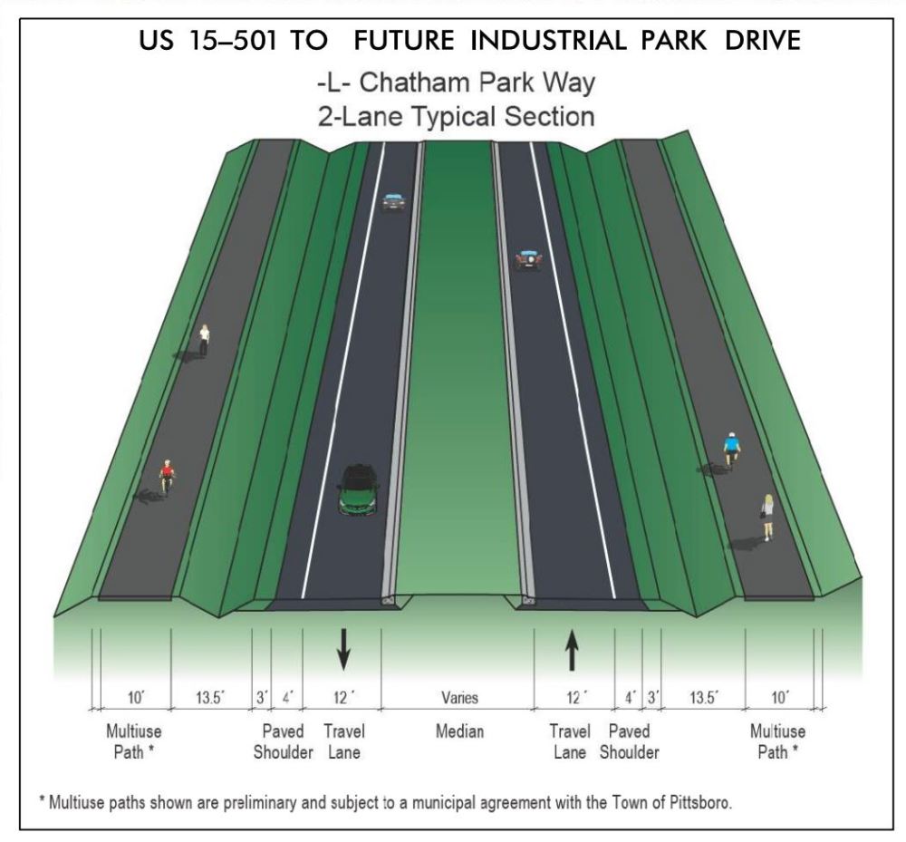
Roadway - U.S. 15-501 south of Pittsboro to future Industrial Park Drive
This section will contain:
- one through lane in each direction separated by a median (width varies)
- curb and gutter on the inside (framing median)
- a 4-foot outside paved shoulder and 3-foot unpaved
- a 10-foot multiuse path on each direction separated from traffic by a 13.5 foot median*
* Multiuse paths shown are preliminary and subject to a municipal agreement with the Town of Pittsboro.
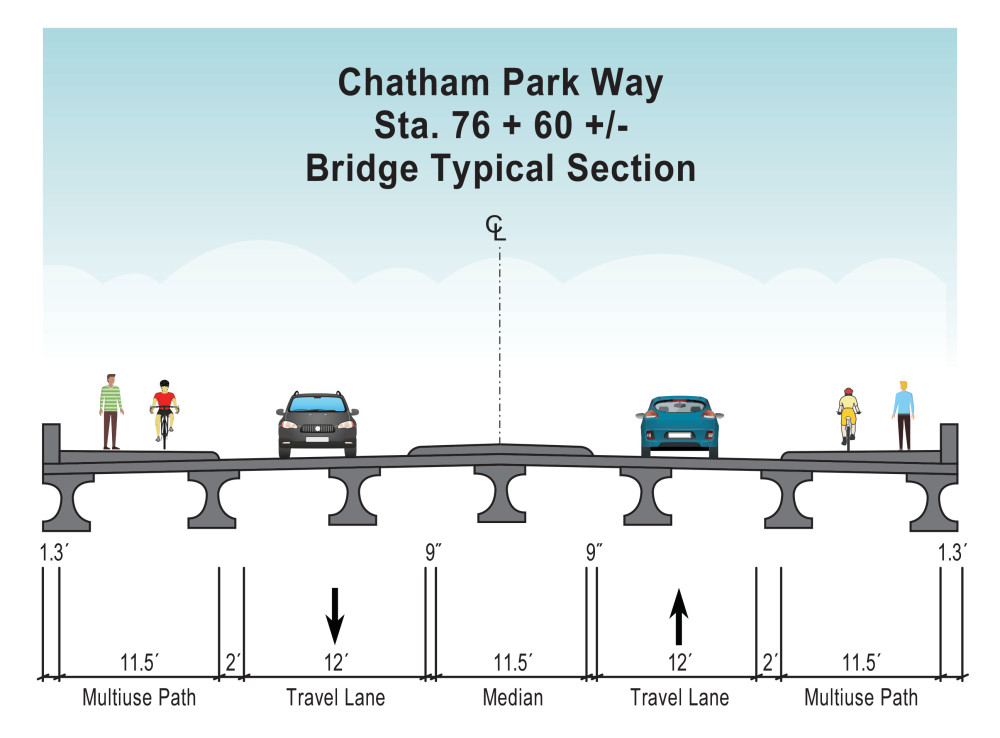
Bridge west of Moncure-Pittsboro Road
Bridge will contain
- one through lane in each direction separated by an 11.5 foot raised concrete median
- an 11.5 foot wide multiuse path on both sides
Roundabout at Moncure-Pittsboro Road
A roundabout is planned at the Moncure-Pittsboro Road intersection, as shown on Map 2 linked above. The roundabout will have one travel lane around the circle, and the multiuse path will cross all four roadway legs.
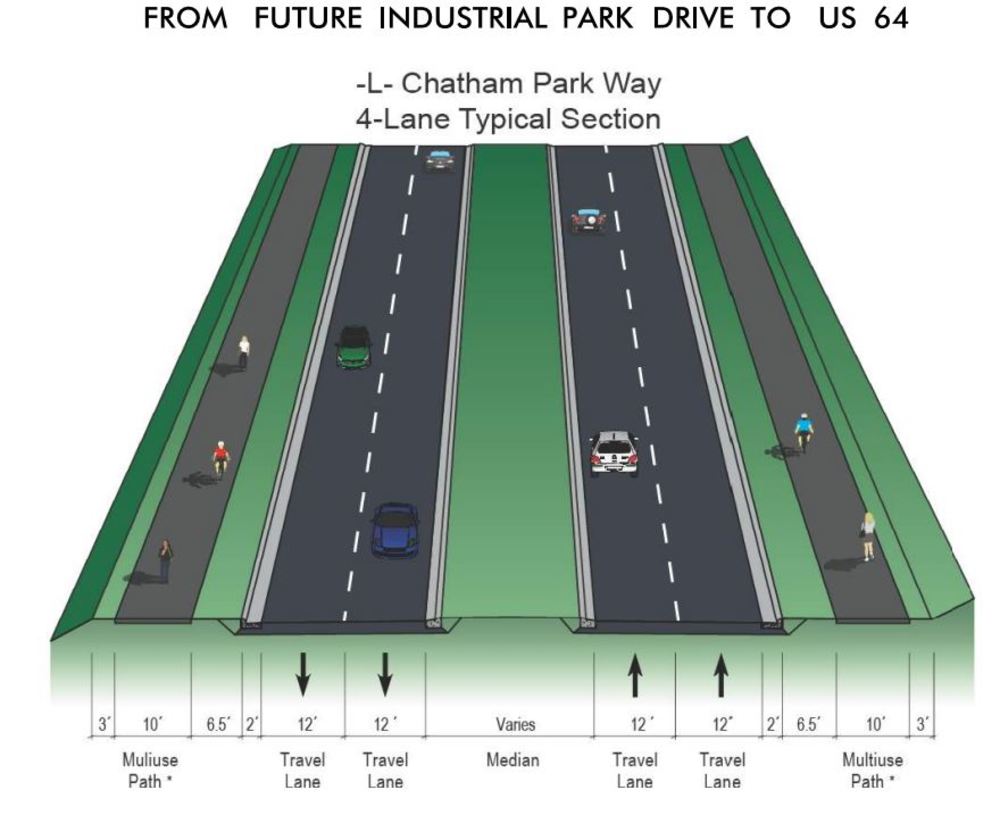
Roadway - future Industrial Park Drive to U.S. 64
This section will contain:
two through lanes in each direction separated by a median (width varies)
curb and gutter on both sides of roadway
a 10-foot multiuse path on each direction separated from traffic by a 6.5-foot median*
* Multiuse paths shown are preliminary and subject to a municipal agreement with the Town of Pittsboro.
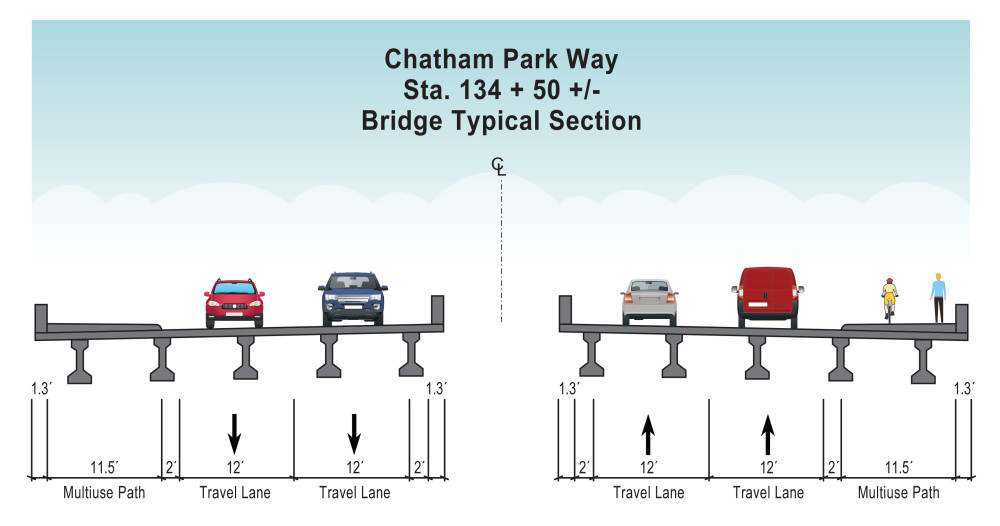
Bridge Over Roberson Creek
Bridge will contain
two bridges separated by 11.5 feet
two through laneson each bridge
- an 11.5-foot wide multiuse path on both sides
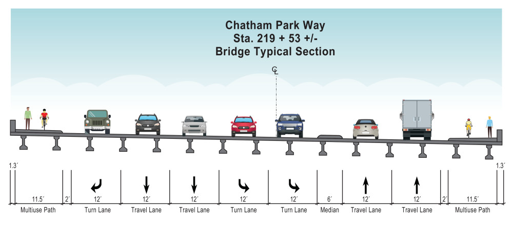
Bridge Widening North of Wendover Parkway
Bridge will contain
2 through lanes in each direction
an 11.5-foot multiuse path on both sides
a 6-foot raised concrete median
Southbound section of bridge will also contain a right lane for turns onto Wendover Parkway and 2 left turn lanes onto future Wendover Parkway
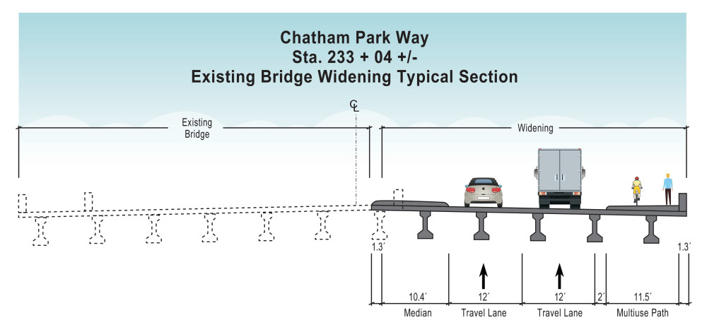
Bridge Widening Over U.S. 64
A new bridge will be built to the east of the existing bridge. After it is built, existing northbound traffic will be moved from the existing bridge to the new bridge, and the existing bridge will carry two lanes of southbound traffic instead of one. The bridge extension will contain
- 2 through lanes
- a 10.4 foot raised concrete median on the inside which combined with existing bridge will create an 11.5-foot area between directions of travel
- an 11.5-foot multiuse path
Project Funding
Project R-5963 is listed in the currently adopted State Transportation Improvement Program (STIP).
| Estimated Amount* |
Development & Design | $ 9.6 Million |
Right-of-Way Acquisition | N/A |
Construction Costs Phases A and B Phase C Phase D |
$ 66.1 Million $ 32.1 Million $ 6.7 Million |
Total Cost | $ 114.5 Million |
* Estimated costs are preliminary and subject to change
Costs shown are rounded
Project Timeline
Milestone | Date* |
Environment Document | March 2023 |
Right-of-Way Acquisition Begins | N/A
|
Construction Begins Phase A Phase B Phase C Phase D | April 2024 March 2025 March 2025 TBD** April 2024 |
* Schedule is preliminary and subject to change
** Section C will be rescored during the upcoming round of STIP development
Project Comments
NCDOT accepts comments throughout all phases of project development.
All comments will be taken into consideration, and carry equal weight, regardless of submittal method.
To submit comments for consideration during the current phase of project development,
please submit before NEED DATE
The public is encouraged to leave comments using this webpage, email, or phone number:
or mailed to the project contacts at the addresses listed below.
Email: South-Chatham-Park-Way@PublicInput.com
Phone Number: 984-205-6615 enter project code 2966 to leave a message
Project Contact
Jeffrey Stroder
NCDOT Division 8
Division Project Manager
121 DOT Drive
Carthage, NC 28327
Project Contact
Vance Blanton
Kimley-Horn
Consultant Project Manager
421 Fayetteville Street, Suite 600
Raleigh, NC 27601
Title VI Feedback
To ensure we’re hearing from a broad set of voices, would you be willing to share (completely anonymously) some information about yourself?
If so, please click here: https://publicinput.com/NCDOT-Title-VI
RESOURCES FOR PROPERTY OWNERS
Although the N.C. Department of Transportation works to minimize the number of homes and businesses displaced by a road project, it is inevitable, in many cases, that a certain amount of private property is needed. The following information explains right of way acquisition and answers questions about the process.
Right-of-Way Brochure Single Page Layout Folleto del Proceso de Adquisición de Bienes Raíces
Right-of-Way Frequently Asked Questions
Right of way Acquisition Process Videos