 I-5990 - I-40 at Old N.C. 10 Interchange Improvements- Hildebran
I-5990 - I-40 at Old N.C. 10 Interchange Improvements- Hildebran
Proposal to improve Exit 118 on I-40 at Old N.C. Highway 10 and replace bridge over I-40.
Vicinity Map:
Project Overview
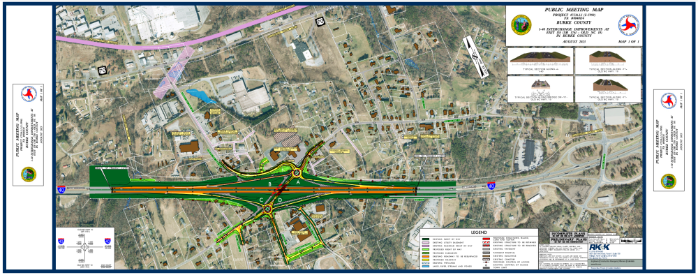
The N.C. Department of Transportation proposes to improve the I-40 Interchange with Old N.C. Highway 10 (S.R. 1761) (Exit 118) and replace the existing bridge on Old N.C. Highway 10 over I-40 within and adjacent to the Town of Hildebran in Burke County.
This project proposes to realign existing ramps and approaching roadways.
A public meeting was held in November 2022 at which one alternative was presented. An additional alternative has been developed and is shown below.
Alternative 1 (November 2022 Public Meeting)
- The connection of Curleys Fish Camp Road to the existing I-40 ramp would be eliminated. Access to residences and businesses on Curleys Fish Camp Road would be rerouted via U.S. 70, Third Street SW, and Old N.C. Highway 10.
- Dietz Avenue, a service road along the south side of I-40, would be extended to Old Brittain Road to provide a connection to Old N.C. Highway 10. Martin Fish Pond Street and Dowell Street would terminate at intersections with Dietz Road Extension.
- Existing traffic could be maintained so that Exit 118 would not need to be closed during construction.
Alternative 2 (August 2023 Public Meeting)
- Old N.C. Highway 10 and I-40 ramps would connect via roundabouts on each side of I-40. Curleys Fish Camp Road would connect to the roundabout north of I-40 and Dowell Street would connect to the roundabout south of I-40.
- The connection of Martin Fish Pond Street to Old N.C. Highway 10 would be eliminated. A new connector road is proposed from Martin Fish Pond Street to Dowell Street.
- Exit 118 would need to be closed to traffic during construction.
Both of the alternatives would replace the existing Old N.C. Highway 10 bridge over I-40 and realign existing ramps and approaching roadways.
Project Map
Click on the link to view or download the maps. You can also view maps by clicking on thumbnails.
Project Map: Proposed Improvements to I-40 Interchange with Old N.C. Highway 10 (Exit 118)
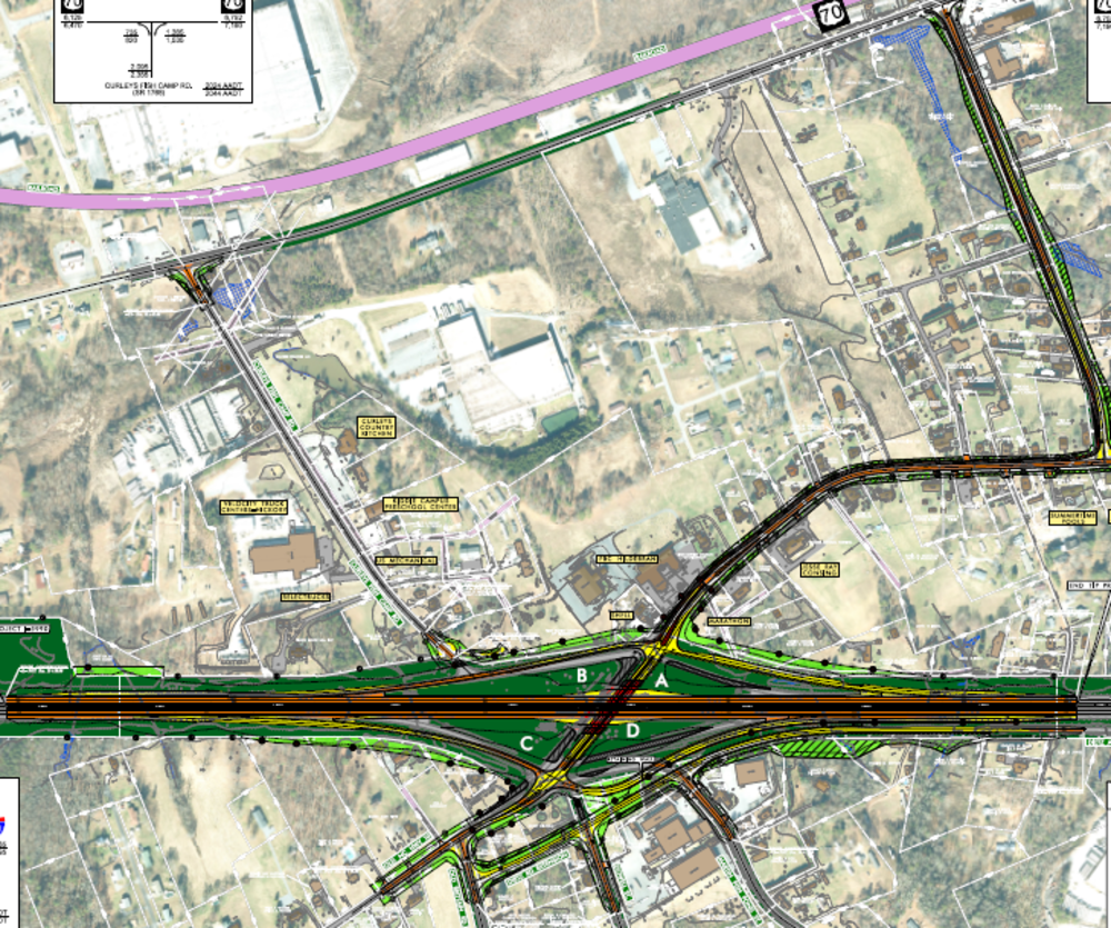
Alternative #2 Project Map
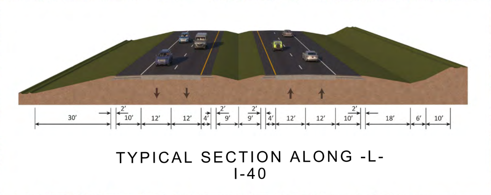
Alternative #2 Typical Sections
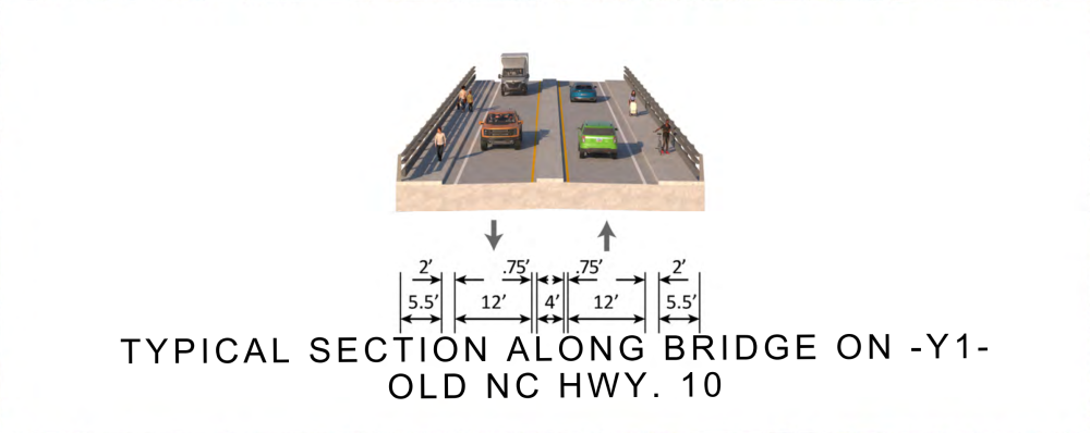
Alternative #2 Typical Sections
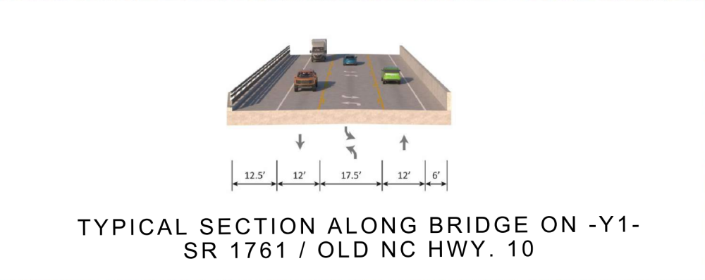
Old N.C. Highway 10 Bridge over I-40 will be improved to Two 12-foot-wide travel lanes in each direction, a 4-foot-wide center concrete median, and a 5.5-foot-wide sidewalks on both sides of the bridge or 5.5-foot-wide sidewalk on the northwest side of the bridge and paved shoulder on the southeast side of the bridge
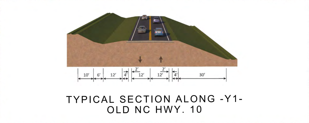
Alternative #2 Typical Sections
South of the I-40 interchange will improve to Two 12-foot-wide travel lanes, a 4-foot-wide grassed shoulders, and 2-foot-wide paved shoulders
Alternative #2 Typical Sections
North of the I-40 interchange wil improve to Two 12 foot-wide travel lanes, Curb and gutter and a 5-foot-wide siewalk on the northwest side, and a 6-foot shoulder (2-foot-wide paved, 4-foot-wide grassed) on the southeast side
Alternative #1 Project Map
Alternative #1 Typical Sections

Alternative #1 Typical Sections
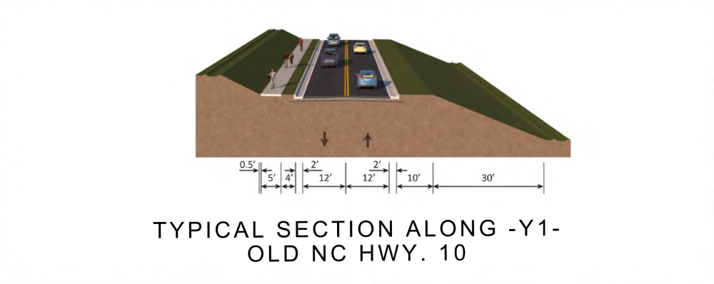
Southwest of the interchange, outside of the town, Old N.C. Hwy. 10 will be improved with 4-foot-wide grassed shoulders, 2-foot-wide paved shoulders and two, 12-foot-wide travel lanes
Alternative #1 Typical Sections
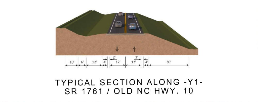
Proposed improvements to Old N.C. Hwy. 10 northeast of the I-40 interchange will include a 5-foot-wide sidewalk on the north side, two 12-foot-wide travel lanes, curb and gutter and a 10-foot-wide grass shoulder on the south side, consistent with the urban context within the municipal limits of Hildebran and local input.

Alternative #1 Typical Sections
Project Funding:
Activity | Funded Costs* |
Construction | $ 26,200,000 |
*Funded costs are subject to change.
Project Timeline:
Milestone | Date* |
Public Meeting | Nov. 2022 |
Environmental Document | Sept. 2022 |
Right-of-Way Acquisition Begins | Sept. 2023 |
Construction Begins | Sept. 2024 |
* Future dates subject to change.
Comments:
NCDOT accepts comments throughout all planning, design, and construction phases of project development.
All comments will be taken into consideration, and carry equal weight, regardless of submittal method.
Comments on the current phase of project development were submitted by September 6, 2023.
PROJECT CONTACT INFORMATION
Brendan Merithew
Project Engineer
NCDOT Highways Division 13
55 Orange Street
Asheville, NC 28801
PROJECT CONTACT INFORMATION
Mark Pierce, PE
Project Manager
RK&K
8601 Six Forks Road, Forum 1, Suite 700
Raleigh, NC 27615
RESOURCES FOR PROPERTY OWNERS
Although the N.C. Department of Transportation works to minimize the number of homes and businesses displaced by a road project, it is inevitable, in many cases, that a certain amount of private property is needed. The following information explains right of way acquisition and answers questions about the process.
Right-of-Way Brochure Single Page Layout Folleto del Proceso de Adquisición de Bienes Raíces
Right-of-Way Frequently Asked Questions
Right of way Acquisition Process Videos
Title VI Feedback
To ensure we’re hearing from a broad set of voices, would you be willing to share (completely anonymously) some information about yourself?
If so, please click here https://publicinput.com/NCDOT-Title-VI