 U-5998: N.C. 42 Buffalo Rd to Wilson County Line
U-5998: N.C. 42 Buffalo Rd to Wilson County Line
Proposed improvements to N.C. 42 from Buffalo Road to Wilson County Line in Johnston County.
Step 1
Interactive Project Study Area Map
This map is for reference only and is a representation of the general project area.
Project Overview
The N.C. Department of Transportation proposes to improve N.C. 42 from Buffalo Road to Wilson County Line, at nine (9) total sites, in Johnston County. The project is 10.32 miles long. The description of upgrades at each location is below:
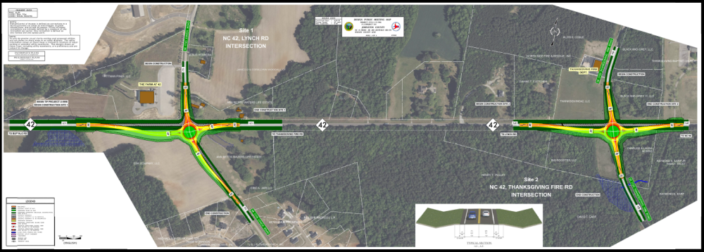
Map 1 - N.C. 42 and Lynch Road - Create roundabout and roadway/shoulder widening.
Map 1 - N.C. 42 and Thanksgiving Fire Road (S.R. 1720) - Create roundabout and roadway/shoulder widening.
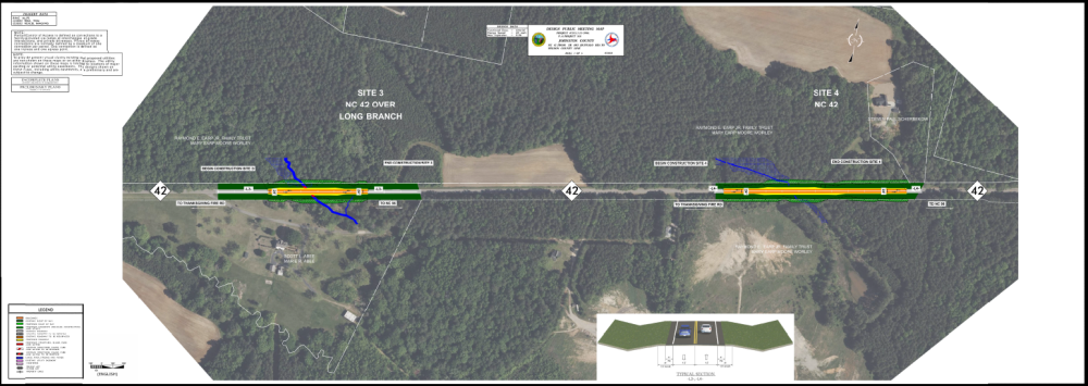
Map 2 – N.C. 42 at Long Branch Creek - Extend 2 culverts, roadway/shoulder widening and added guardrail.
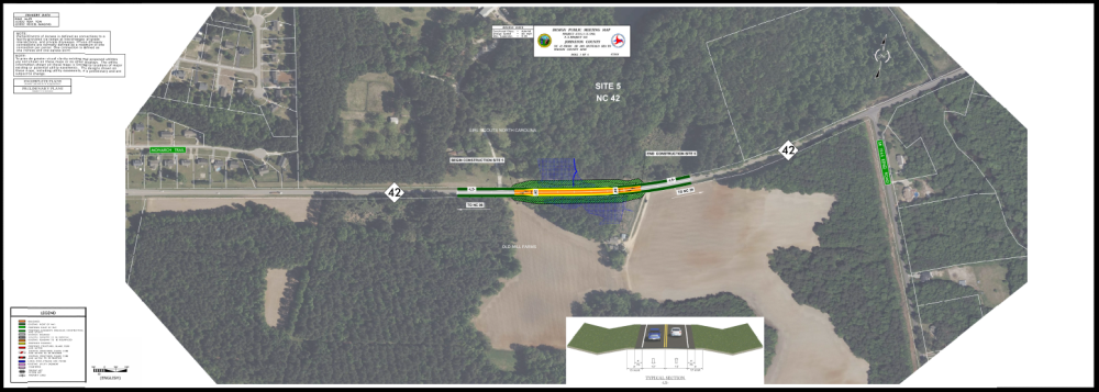
Map 2 – N.C. 42 west of N.C. 96 – Roadway/shoulder widening and added guardrail.
Map 3 – N.C. 42 – Roadway/shoulder widening and added guardrail.
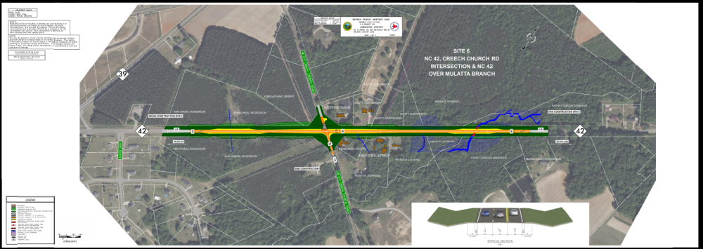
Map 4 – N.C. 42 and Creech Church Road (S.R. 2117) – Turn lanes on N.C. 42, two RCBC at Little River tributary, remove northern section of Creech Rd. due to fatal accidents.
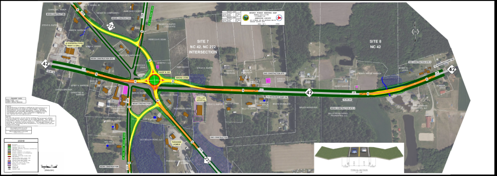
Map 5 – N.C. 42 and NC 222 W/Raper Rd./Old Beulah Rd. – Roundabout/realignments/turn lanes/medians.
Map 5 – N.C. 42 East of Jerusalem Church Rd. (S.R. 2186) - replacing culvert carrying Little Buffalo Creek under N.C. 42 and Roadway/shoulder widening and added guardrail.
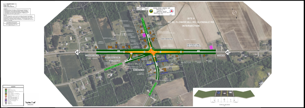
Map 6 - N.C. 42 and Glendale Rd./Flower Hill Rd. (S.R. 2110) – Turn Lane Improvements on N.C. 42.
N.C. 42 and NC 222W/Raper Rd. (SR 2113)/Old Beulah Rd. (SR 1934) – Roundabout/realignments/turn lanes/medians.
N.C. 42 East of Jerusalem Church Rd. (SR 2186) - Pipe E2059 at Little Buffalo Creek and Roadway/shoulder widening and added guardrail.
N.C. 42 and Glendale Rd./Flower Hill Rd. (SR 2110) – Turn Lane Improvements on N.C. 42.
The construction phase is expected to take 3 years.
To view or download project map 3 click here or on the map below
To view or download project map 4 click here or on the map below
Project Funding:
Activity | Costs* |
Utility Relocation | $ 2.10 Million |
Right-of-Way Acquisition | $ 3.30 Million |
Construction | $ 30.10 Million |
Total Cost | $ 35.40 Million |
*costs are subject to change.
Project Timeline:
Milestone | Date* |
Environmental Document | Spring 2025 |
Right-of-Way Acquisition Begins | Summer 2025 |
Construction Begins | August 2027 |
* Future dates subject to change.
Project Comments:
NCDOT accepts comments throughout all phases of project development.
All comments will be taken into consideration, and carry equal weight, regardless of submittal method.
Comments for consideration during the current phase of project development
were to be submitted by April 11, 2025.
The public is encouraged to leave comments using this email or phone number:
Email: nc42-buffalord@publicinput.com
Phone Number: 512-580-8850 and enter project code to leave a message 10982
Project Contact Information
Donald "Chad" Edge
Project Engineer
NCDOT Highway Division 4
PO Box 3165
Wilson, NC 27895
Project Contact Information
Marc Hamel
Consultant Project Manager
Moffatt & Nichol
4700 Falls of Neuse Road, Suite 300
Raleigh, NC 27609
Title VI Feedback
To ensure we’re hearing from a broad set of voices, would you be willing to share (completely anonymously) some information about yourself?
If so, please click here: https://publicinput.com/NCDOT-Title-VI-Form
RESOURCES FOR PROPERTY OWNERS
Although the N.C. Department of Transportation works to minimize the number of homes and businesses displaced by a road
project, it is inevitable, in many cases, that a certain amount of private property is needed. The following information explains right
of way acquisition and answers questions about the process.
Right-of-Way Brochure Single Page Layout Folleto del Proceso de Adquisición de Bienes Raíces
Right-of-Way Frequently Asked Questions
Right of Way Acquisition Process Videos
Page last updated: July 13, 2026
ADA Compliant