 HE-0001: New I-26 Interchange - Buncombe Co.
HE-0001: New I-26 Interchange - Buncombe Co.
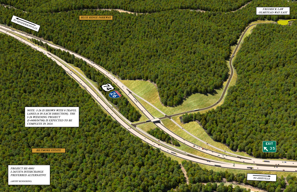
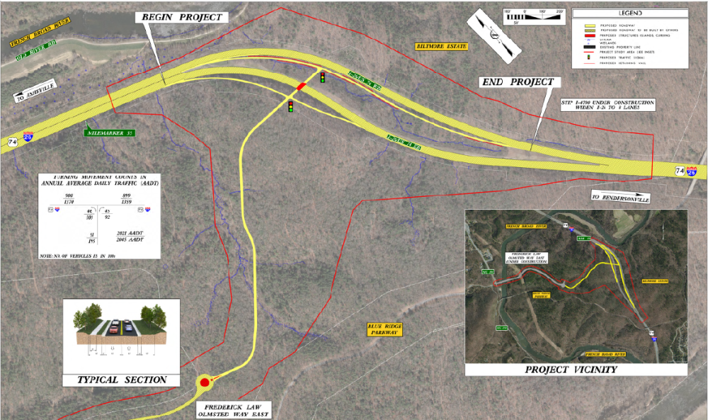
The N.C. Department of Transportation proposes to construct a new interchange along Interstate 26 and a roadway extension to connect with a future state road, Frederick Law Olmsted Way East, which connects to N.C. 191 in Buncombe County, NC. The project is located approximately 6 miles south of Asheville along I-26 near mile marker 35, north of the Blue Ridge Parkway and south of the I-26 bridge over the French Broad River. The purpose of the proposed project is to address the lack of network connectivity between N.C. 191 and I-26 in southern Buncombe County and to accommodate current and planned growth.
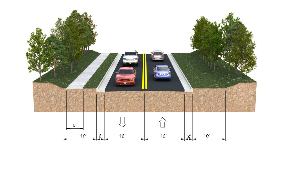
The Biltmore Park West property, located between I-26 and N.C. 191 in this area, is currently under development. The property will be accessed via a new roadway intersecting N.C. 191 at Frederick Law Olmsted Way. The private developer is currently constructing a new bridge over the French Broad River and the new 2 lane road, Frederick Law Olmsted Way East, to connect to the Pratt & Whitney Manufacturing Center, also currently under construction.
As with many private development projects where NCDOT anticipates accepting ownership of the roadway infrastructure, NCDOT has reviewed and approved all preliminary plans for the French Broad River bridge and new roadway and has an inspector on-site to confirm that the privately-built transportation infrastructure is constructed to NCDOT standards. The proposed project would construct a new interchange and two-lane road to connect to Frederick Law Olmsted Way East.
Interactive Study Area Map
Preferred Alternative - Selected
NCDOT and the Federal Highway Administration (FHWA) have selected Interchange Concept 3 as the Preferred Alternative for the new I-26 interchange project.
The Preferred Alternative includes:
Left exit/entrance ramps connecting to I-26 Asheville bound (westbound) traffic
Location at the north end of the I-26 divided section, south of the French Broad River and north of the Blue Ridge Parkway
NCDOT is evaluating the Preferred Alternative interchange configuration (e.g., diamond interchange, diverging diamond interchange) based on detailed traffic operations analysis.
The Preferred Alternetive was selected based on:
Assessment of the comments received during the Public Comment Period
Review of the results of the potential impact assessment for the three interchange concepts
In conjunction with federal and state environmental agency partners, Interchange Concept 3 was determined the least Environmentally Damaging Alternative
Preferred Alternative - Impacts
|
|
|---|---|
Jurisdictional Waters - Stream Total (ft) | 1,500 |
Jurisdictional Waters - Wetland Total (acre) | 0.1 |
FEMA Floodplain (acre) | 0 |
Biltmore Estate National Historic Landmark (NHL) (acre) | 0 |
Preferred Alternative - Design Refinements
NCDOT has refined the Interchange Concept 3/Preferred Alternative in the following ways:
Shifted the interchange about 300 feet to the south
skewed the interstate bridge/overpass to the south
Shifted the on- and off-ramps to the east
Lengthened the on- and off-ramps
A video explaining how to read a public hearing or public meeting map can be viewed below.
Diverging Diamond Interchange
A diverging diamond interchange allows two directions of traffic to temporarily cross to the left side of the road. It moves high volumes of traffic through an intersection without increasing the number of lanes and traffic signals. This movement provides easier access to an interstate.
For more information on Diverging Diamond Intersections, please watch the following video or visit the NCDOT Diverging Diamond Webpage.
Public Comment Summary
General safety of merging out of and into the left lane (high speed lane) for Interchange Concepts 1 and 3 (left exit concepts), specifically related to truck traffic (lane restrictions, weaving, and steep grades)
The shorter length of the merge lanes and ramps for Interchange Concept 3
NC 191 (Brevard Road) congestion, both increasing and decreasing because of the proposed project
Local transportation project priorities
Funding
Environmental impacts
Please refer to the Public Comment Summary for a complete review of public comments received and NCDOT’s responses to the questions and comments raised during the public comment period.
Project Funding
| Estimated Amount* |
|---|---|
Project Development & Design | $3,127,200 |
Right-of-Way | $100,000 |
Construction | $25,200,000 |
Total | $28,427,200 |
* Costs are preliminary and subject to change
Project Timeline
Milestone | Date* |
|---|---|
Public Comment Period | Summer/Fall 2021 |
Selection of Preferred Alternative | Winter 2021 - 2022 |
Environmental Document | Spring 2022 |
Construction | Summer 2023 |
* Future dates are preliminary and subject to change
Project Contact
McCray Coates, PE
NCDOT Project Manager
55 Orange Street
Asheville, NC 28801
I26-exit35-buncombe@publicinput.com
984-205-6615 code 8908
Title VI Feedback
To ensure we’re hearing from a broad set of voices, would you be willing to share (completely anonymously) some information about yourself?
If so, please click here: https://publicinput.com/ncdot-title-vi-form
RESOURCES FOR PROPERTY OWNERS
Although the N.C. Department of Transportation works to minimize the number of homes and businesses displaced by a road project, it is inevitable, in many cases, that a certain amount of private property is needed. The following information explains right of way acquisition and answers questions about the process.
Right-of-Way Brochure Single Page Layout Folleto del Proceso de Adquisición de Bienes Raíces
Right-of-Way Frequently Asked Questions
Right of way Acquisition Process Videos
Page Last Updated- May 4 2026