 U-5811: Aviation Parkway
U-5811: Aviation Parkway
This project proposes to widen approximately 2.4 miles of Aviation Parkway from N.C. 54 (Chapel Hill Road) in Morrisville to I-40 in Cary.
The final responses to comments summary report can be viewed or downloaded here.
Step 1
Interactive Project Study Area Map
Project Overview
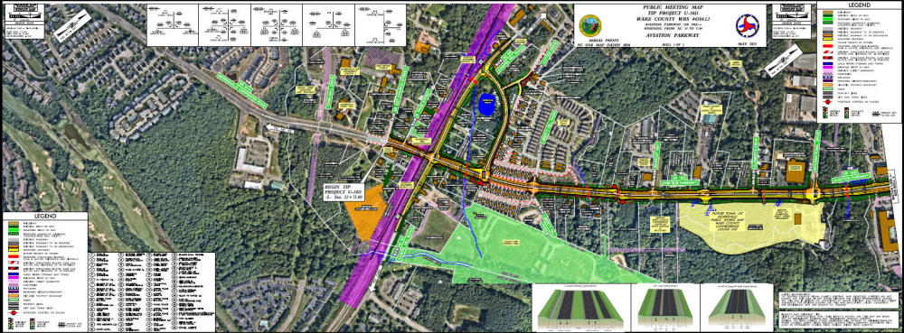
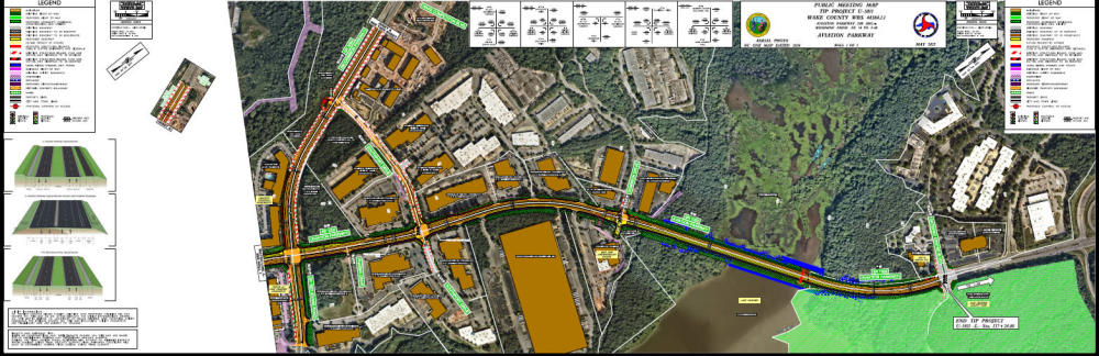
This project proposes to widen approximately 2.4 miles of Aviation Parkway (S.R. 1002) from N.C. 54 (Chapel Hill Road) in Morrisville to I-40 in Cary. The existing roadway will be widened to a four-lane, median-divided roadway with bicycle and pedestrian facilities. A quadrant-loop intersection is proposed at the intersection of Aviation Parkway and N.C. 54, and N.C. 54 is proposed to be shifted slightly to the east to create a greater separation between the railroad and roadway.
The primary purpose of this project is to reduce congestion on Aviation Parkway and improve the level of service (LOS) in the design year (2050) peak hours along the corridor and at signalized intersections. Another purpose of this project is to improve east-west mobility through Morrisville and to I-40 and I-540/NC 540. With adjacent recently completed projects in conjunction with U-5811, the Aviation Parkway/Morrisville Carpenter Road corridor will be a 4-lane median divided arterial road from Davis Drive to Brier Creek.
The handouts from the May 12, 2025 public meeting can be viewed by clicking on any of the folowing languages that is your preferance, Vietnamese, Mandarin, Hindi, or English.
Project History
The project began in 2015. Project Design, environmental analysis, and public engagement was conducted until the project was suspended in 2019. The project was restarted in 2023. Key dates are listed below:
- Winter 2015 through Fall 2019 – NCDOT collected data on existing conditions, developed preliminary designs, and calculated potential impacts
- February 2016 – NCDOT held public informational meeting #1
- June 2019 – NCDOT held public informational meeting #2
- Fall 2019 – Project suspended by NCDOT
- June 2023 – NCDOT restarted project development activities
- June 2023 through present day – NCDOT design redevelopment, updated agency coordination, and recalculation of impacts
Project Highlights
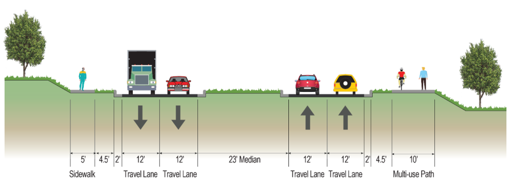
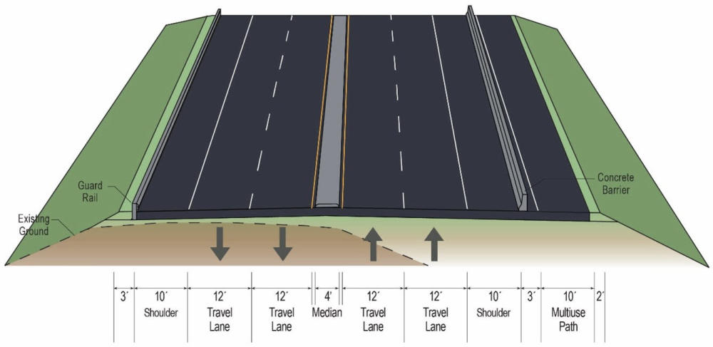
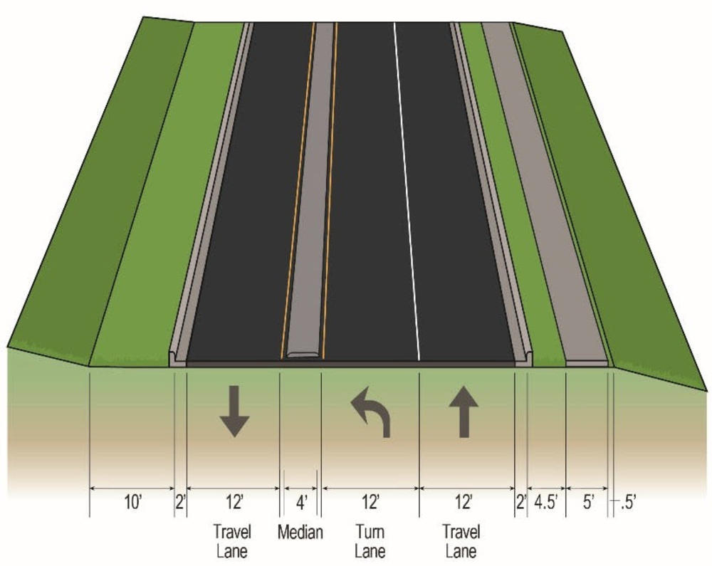
Aviation Parkway will be upgraded to a four-lane, median divided roadway with a 10-foot multi-use path on the south side and a 5-foot sidewalk on the north side. Left turns will not be allowed at Aviation Parkway/N.C. 54, but instead will be accommodated through a new, short loop road (“quadrant-loop”). Additionally, widening of Aviation Parkway will include widening across the Lake Crabtree causeway. The current design calls for replacement of the existing culvert across the causeway, resulting in causeway closure during construction efforts.
The project will tie into the Aviation Parkway/I-40 interchange improvement project (STIP No. I-5506), which was recently completed.
Project Maps
Clicking on the maps will enlarge them for easier viewing.
Typical Sections
Aviation Parkway
Lake Crabtree Causeway
N.C. 54 Quadrant Loop
Project Timeline
Milestone | Date |
In-Person Local Officials/Public Meeting | May 2025 |
Federal Environmental Document | Winter 2025 |
Right-of-Way Acquisition Begins | Fall 2026 |
Utility/Railroad Certification | Fall 2027 |
Construction Begins | Summer 2029 |
* Future dates are preliminary and subject to change
Project Funding
This project is listed as Project U-5811 in the N.C. Department of Transportation’s State Transportation Improvement Program and is funded for $89.8 million.
| Estimated Amount* |
Utilities | $ 2.6 Million |
Property Acquisition | $27.7 Million |
Construction Costs | $59.5 Million |
Total Costs | $89.8 Million |
* Costs are preliminary and subject to change
Project Contact Information
Joel Perlin, PMP
NCDOT Project Manager
NCDOT Project Management Unit
1582 Mail Service Center
Raleigh, NC 27699-1582
Public Involvement
NCDOT began the planning and design phase for this project in late 2015. The first public meeting was held in February 2016. At this meeting, the project team presented the study area and the purpose of the project. The public was asked for their concerns and needs along the corridor. A second public meeting was held on June 12, 2019. At this meeting, the project team presented two options for the NC 54 quadrant loop. The third public meeting was held on May 12, 2025. At this meeting, the project team hosted a public open house with stations where community members could learn about key design changes and view the preferred project design.
Comments/Questions
Any additional comments may be submitted via:
- U.S. Mail to the Project Manager listed at the bottom of this page;
- email to aviationparkway@publicinput.com;
- or at any meeting;
- or Phone Number: 984-205-6615 enter project code 11379 to leave a message
All comments received carry equal weight, regardless of submission method.
All comments will be reviewed and suggestions/recommendations incorporated into designs where feasible.
Comments for this phase of project development were due by May 30, 2025.
Title VI Feedback
To ensure we’re hearing from a broad set of voices, would you be willing to share (completely anonymously) some information about yourself?
If so, please click here: https://publicinput.com/ncdot-title-vi-form
RESOURCES FOR PROPERTY OWNERS
Although the N.C. Department of Transportation works to minimize the number of homes and businesses displaced by a road project, it is inevitable, in many cases, that a certain amount of private property is needed. The following information explains right of way acquisition and answers questions about the process.
Right-of-Way Brochure Single Page Layout Folleto del Proceso de Adquisición de Bienes Raíces
Right-of-Way Frequently Asked Questions
Right of way Acquisition Process Videos
Documents
Page Last Updated- April 29 2026