 U-6203: N.C. 210 Improvements - Johnston County
U-6203: N.C. 210 Improvements - Johnston County
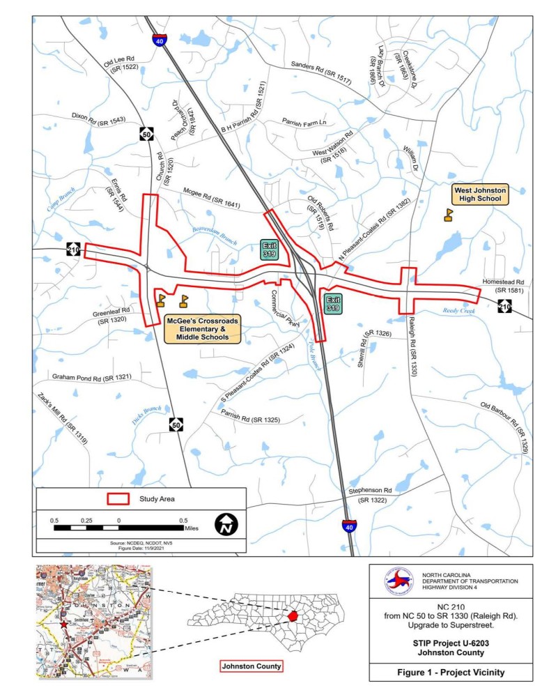
Project Study Area Map
This map is for reference only and is a representation of the general project area.
Project Overview
The N.C. Department of Transportation is studying improvements to N.C. 210 between N.C. 50 and Raleigh Road (S.R. 1330) in Johnston County as State Transportation Improvement Program (STIP) Project U-6203. The N.C. 210 corridor is currently experiencing congestion and delays, which are anticipated to worsen by the project design year of 2045. The proposed improvements are therefore needed to alleviate existing and projected traffic congestion in the project area. As a secondary benefit, the proposed project may improve safety of the N.C. 210 corridor within the project limits.
After the public meeting held on December 13, 2022 the preferred alternative selected was Alternative 4.
Project Highlights
Project U-6203 proposes the following improvements:
Widen N.C. 210 from two to four 11-foot travel lanes between N.C. 50 and Raleigh Road
Improve the intersections at N.C. 50, Pleasant Coates Road, and Raleigh Road
Reconfigure the I-40 (Exit 319) interchange
The proposed roadway typical section along N.C. 210 includes four 11-foot travel lanes with a raised median and five-foot paved shoulders.
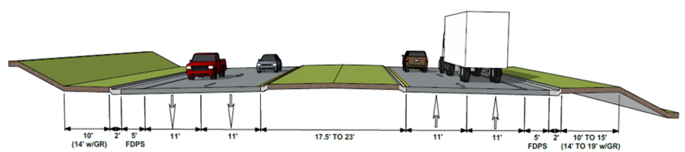
To improve traffic operations and safety, Reduced Conflict Intersection design components (also known as a superstreet) are proposed throughout the project corridor.
Project History
Initial field surveys to identify environmental resources were conducted within the project area from late 2021 through early 2022. Following the development of preliminary roadway design plans, an informational project newsletter was mailed to residents and business owners in the project vicinity in September 2022. A Public Meeting was held on December 13, 2022, during which a total of four roadway design alternatives were presented to participants.
These four alternatives, which focused on the intersections of N.C. 210/N.C. 50 and the interchange at N.C. 210/Interstate 40, included:
NC 50 Intersection
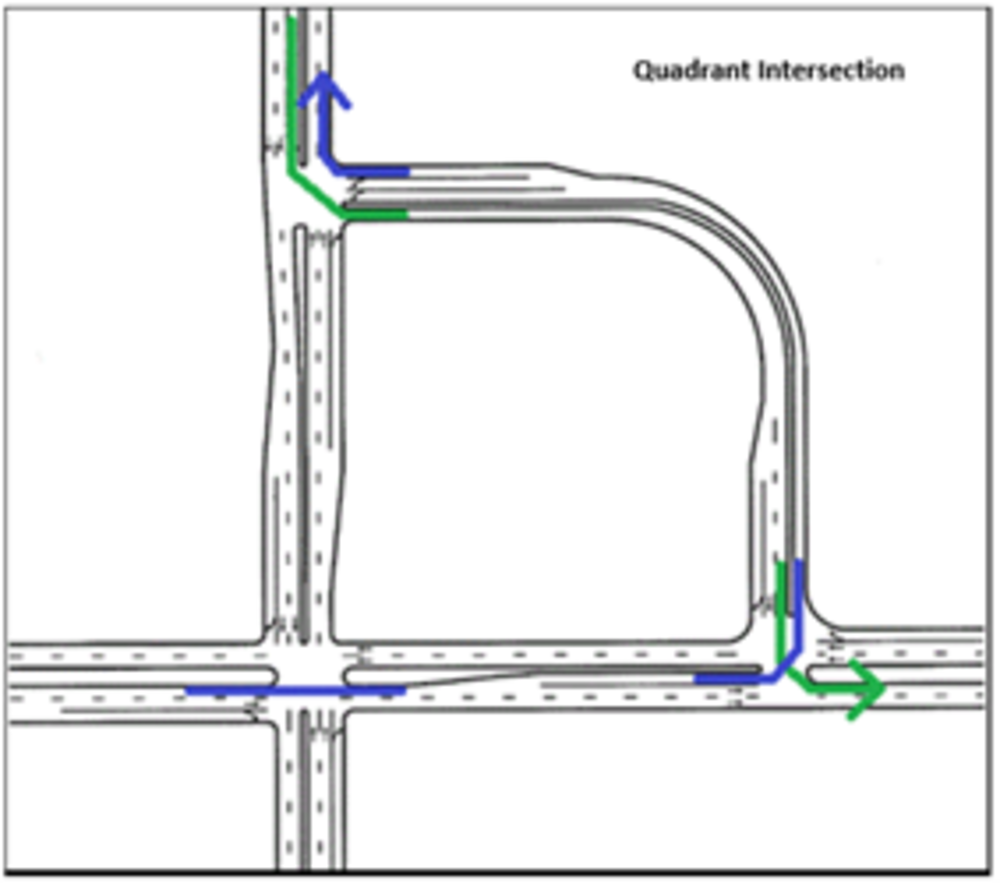
Alternatives 1 and 3: Quadrant Left Turn
This option would construct a quadrant road on new location in the northeastern corner of the intersection with N.C. 50. Quadrant roads help to improve operational efficiency at congested intersections by moving the left turns away from the main intersection and allowing a two–phase signal at the main intersection, enabling fewer stoppages and more ‘green time’ for thru-traffic. The driveway to McGee’s Crossroads Elementary and Middle Schools would also be realigned to tie into the new signalized quadrant road intersection approximately 1,100 feet east of the N.C. 50 intersection.
Alternatives 2 and 4: Median U-Turn
Like the quadrant road option, this alternative would permit through and right-turn movements at N.C. 210 and redirect left-turn movements away from the main intersection. To turn left on N.C. 210, drivers along N.C. 50 would first turn right and then utilize signalized U-turn areas to turn around. By removing most of the crossing conflicts, the design typically results in less severe crashes and can accommodate more traffic volume without increased delays. Median U-turn intersection designs can reduce travel time during peak conditions and increase travel speed on congested corridors.
I-40 Interchange
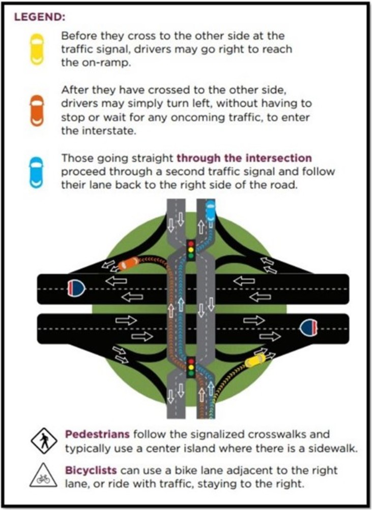
Alternatives 1 and 4: Diverging Diamond Interchange
This option would reconstruct the interchange at I-40 as a Diverging Diamond Interchange. A diverging diamond interchange allows two directions of traffic to temporarily cross to the left side of the road. When driving through a diverging diamond interchange, motorists proceed through a traffic signal at the entrance to the interchange and simply follow their lane to the opposite side of the roadway. A diverging diamond interchange allows free-flowing turns when entering and exiting an interstate, eliminating the left turn against oncoming traffic and limiting the number of traffic signal phases. It moves high volumes of traffic through an intersection without increasing the number of lanes and traffic signals. It is easy to navigate, eliminates last-minute lane changes, and provides better sight distance at turns, resulting in fewer crashes.
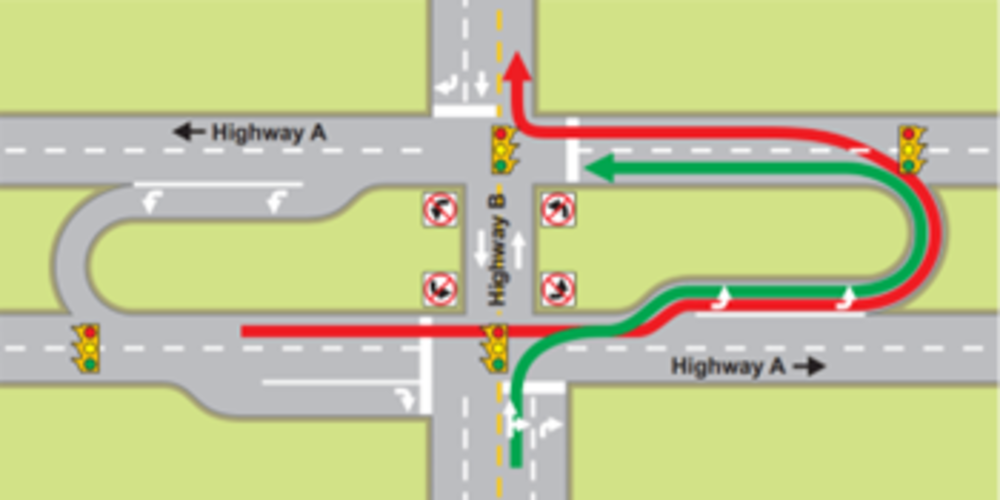
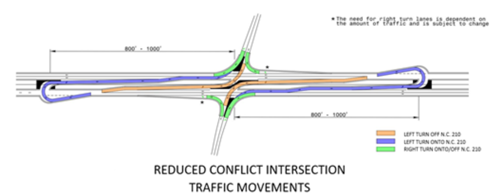
Alternatives 2 and 3: Reduced Conflict Intersection
This option would retain the existing diamond configuration at I-40 while introducing Reduced Conflict Intersection components along N.C. 210 in the vicinity of the interchange. Like the Median U-turn at N.C. 50, drivers exiting I-40 to N.C. 210 would be required to turn right at the main intersection. To travel the other direction along N.C. 210, drivers would then utilize signalized U-turn bulbs to turn around outside of the interchange area. Reduced Conflict Intersection designs allow for fewer phases at traffic signals, which in turn increases the amount of traffic that can be accommodated without delays. They have also been shown to reduce crash rates and improve safety.
Following the Public Meeting, a 30-day comment period was provided during which comments were gathered by the project team, analyzed, and responses provided. Comments received were generally supportive of the need for the project but expressed concerns about potential project impacts. The most frequently expressed concerns were regarding direct impacts to personal property, changes to property access (specifically at the Daniel Farms neighborhood and individual business driveways), questions about the benefits and navigation of Reduced Conflict Intersections (RCIs), questions about the NCDOT right of way acquisition process, and requests for multimodal accommodations along the corridor. Multiple commenters suggested the need for the project to be constructed sooner than currently planned and identified other roadways in the project vicinity for which improvements are needed. Although many commenters did not note a specific alternative preference, the most commonly preferred options were the Median U-Turn Intersection at NC 50 in conjunction with a Diverging Diamond Interchange at I-40 (Alternative 4).
After reviewing public comments, environmental resource impacts, and cost estimates, the project team selected Alternative 4 (Median U-Turn Intersection at NC 50 with a Diverging Diamond Interchange at I-40) as the Preferred Alternative to be carried forward for further design. This decision was documented in the U-6203 Categorical Exclusion, which was completed in April 2023. A postcard was distributed in November 2023 to residents and business owners in the project area to provide an update on project activities.
Download/View All Project Maps
- Map 1: Alternative 1 - Quadrant Left at N.C. 210 and N.C. 50 Intersection
- Map 2: Alternative 1 - Diverging Diamond Interchange at N.C. 210 and I-40 Interchange
- Map 3: Alternative 2 - Median U-turns at N.C. 210 and N.C. 50 Intersection
- Map 4: Alternative 2 - Reduced Conflict Intersections at N.C. 210 and I-40 Interchange
- Map 5: Alternative 3 - Quadrant Left at N.C. 210 and N.C. 50 Intersection
- Map 6: Alternative 3 - Reduced Conflict Intersections at N.C. 210 and I-40 Interchange
- Map 7: Alternative 4 - Median U-turns at N.C. 210 and N.C. 50 Intersection Preferred Alternative
- Map 8: Alternative 4 - Diverging Diamond Interchange at N.C. 210 and I-40 Interchange Preferred Alternative
A video explaining how to read a public hearing or meeting map can be viewed below. The video contains information on colors and symbols used.
Next Steps
The project team is currently developing more detailed roadway design plans that incorporate components such as drainage/utility easements and working to determine the final limits of right of way acquisition. These plans are anticipated to be completed by late 2025. At that time, NCDOT will begin the process of contacting affected landowners to discuss right of way acquisition. Additional information on NCDOT’s right of way acquisition process can be found at the bottom of this page under the ‘Resources For Property Owners’ section. Once right of way acquisition is complete, project construction is scheduled to begin in late 2029. Interested residents and property owners are encouraged to periodically check this project page for updates and project contact information.
Project Funding
Cost* | |
|---|---|
Property Acquisition | $12,800,000 |
Utility Relocation | $4,000,000 |
Construction | $71,600,000 |
Total | $88,400,000 |
* Costs are preliminary and subject to change
Project Timeline
Milestone | Date* |
|---|---|
Project Newsletter | September 2022 |
Public Meeting 1 | December 13, 2022 |
Environmental Document | April 2023 |
Right-of-Way Acquisition Begins | Fall 2026 |
Construction Begins | Fall 2029 |
* Future dates are preliminary and subject to change
Project Comments
NCDOT accepts comments at all times throughout all phases of project development.
Email: NC210Johnston@PublicInput.com
Phone Number: 601-300-5186 enter project code 5122
Project Contact
Chad Coggins
NCDOT Highway Division 4
Division Project Manager
PO Box 3165
Wilson, NC 27895
NC210Johnston@publicinput.com
601-300-5186 code 5122
Project Contact
Abby Vogt, PE
NV5
Consultant Project Manager
PO Box 33127
Raleigh, NC 27636
NC210Johnston@publicinput.com
601-300-5186 code 5122
Title VI Feedback
To ensure we’re hearing from a broad set of voices, would you be willing to share (completely anonymously) some information about yourself?
If so, please click here: https://publicinput.com/NCDOT-Title-VI-Form
RESOURCES FOR PROPERTY OWNERS
Although the N.C. Department of Transportation works to minimize the number of homes and businesses displaced by a road project, it is inevitable, in many cases, that a certain amount of private property is needed. The following information explains right of way acquisition and answers questions about the process.
Right-of-Way Brochure Single Page Layout Folleto del Proceso de Adquisición de Bienes Raíces
Right-of-Way Frequently Asked Questions
Right of way Acquisition Process Videos
Last Updated- February 24 2026