 U.S. 17 Widening, STIP Project Nos. R-2513A and R-3403B
U.S. 17 Widening, STIP Project Nos. R-2513A and R-3403B
Proposed Widening of U.S. 17 from Antioch Road (S.R. 1433) to Spruill Town Road (S.R. 1438)
Preliminary engineering activities for this project
have beeen suspended.
PROJECT OVERVIEW & PURPOSE
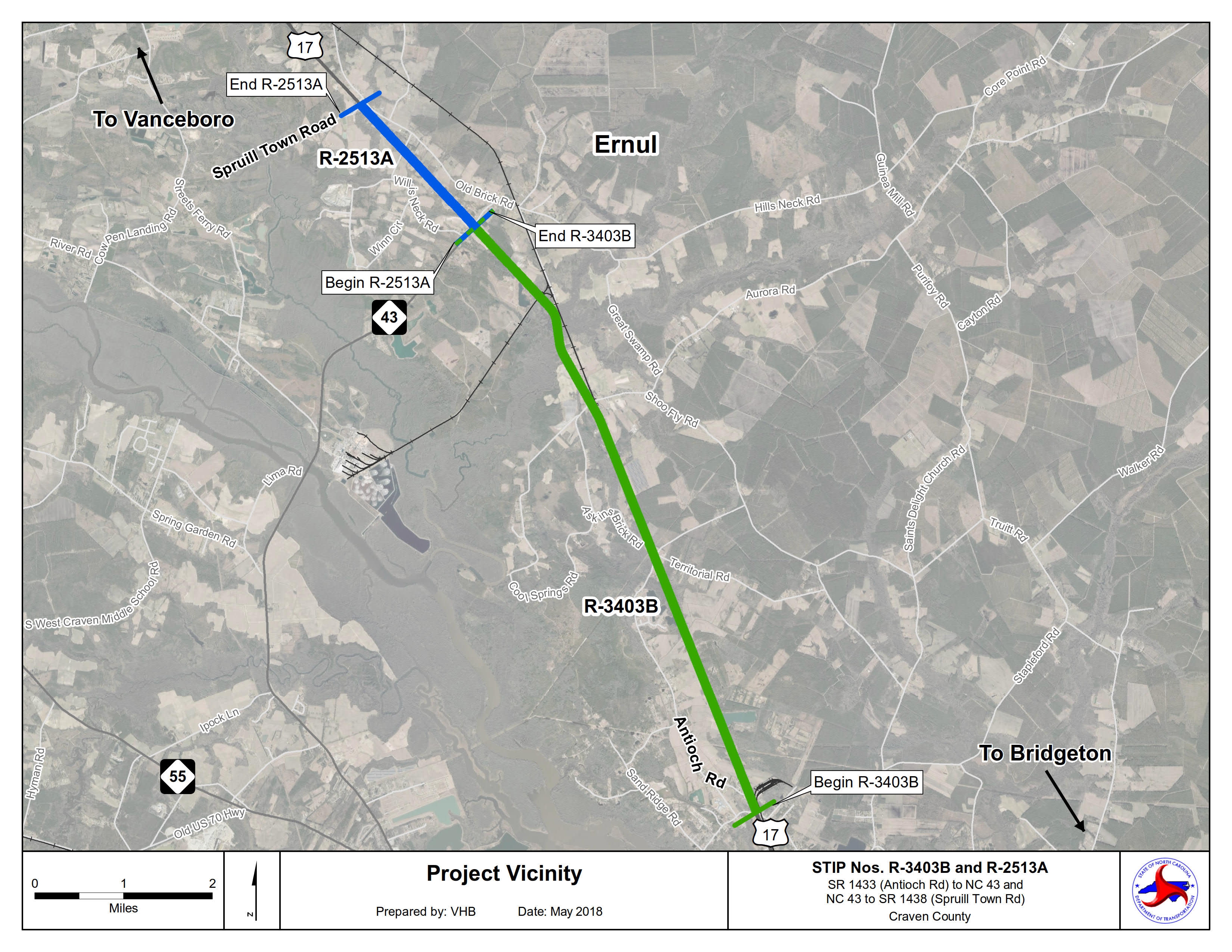
State Transportation Improvement Program (STIP) Project Nos. R-2513A and R-3403B are adjacent widening projects and have similar right-of-way acquisition and construction dates. Project R-3403B widens U.S. 17 from Antioch Road (S.R. 1433) to N.C. 43 and Project R-2513A widens U.S. 17 from N.C. 43 to Spruill Town Road (S.R. 1438). U.S. 17 is the primary north-south transportation corridor in the Coastal Plains, connecting major economic development centers in Virginia and South Carolina with military operations, tourist destinations, and airports in eastern North Carolina. By widening U.S. 17 and partially controlling access, these projects increase mobility and safety, and encourage economic development along the corridor.
VICINITY MAP
PROJECT HIGHLIGHTS
Projects R-2513A and R-3403B will widen U.S. 17 from two 12-foot lanes to four 12-foot lanes with a 30-foot grass median. These projects will tie into the recently widened section of U.S. 17 at Bridgeton, NC, and provide 9 miles of a continuous four-lane roadway to Spruill Town Road. The addition of a median will limit left turns into most driveways along the corridor. U-turn areas will be included to allow turn-around movements at various locations. Full movement, intersections are located along U.S. 17 at: N.C. 43, Ernul Brick Road, Askins Brick Road/Aurora Road, and Antioch Road/Realigned Territorial Road. A grade separation over the existing railroad (operated by Norfolk Southern), just north of Ernul Brick Road will also be included in this project.
PROJECT HISTORY
U.S. 17 which follows a similar, but more scenic route when compared to I-95, runs from Virginia through South Carolina, continuing to Florida. U.S. 17 has been systematically widened with the sections of Projects R-2513A and R-3403B remaining. Project R-3403AA, from Mills Street in Bridgeton to North “C” Street and Project R-3403AB from North “C” Street to North of Antioch Road (S.R. 1433) have been completed. Project R-3403B will continue the U.S. 17 widening, from Antioch Road (S.R. 1433) to N.C. 43, while Project R-2513A will widen U.S. 17 from N.C. 43 to Spruill Town Road (S.R. 1438).
PROJECT FUNDING
R-3403B and R-2513A are funded by the State Highway Trust Funds. Based on preliminary designs, R-3403B is estimated to cost $71.8 million for construction, which includes $6.0 million in Right-of-Way acquisition and $4.5 million for utility relocations. Based on preliminary designs, R-2513A is estimated to cost $15.0 million for construction, which includes $3.0 million for Right-of-Way acquisition and $2.4 million for utility relocations. Both projects will be constructed together and cost approximately $86.8 million total.
PROJECT TIMELINE
Milestone Date*
Public Meeting July 2018
Environmental Document Approval August 2019
Right-of-way Acquisition Begins January 2026
Project Let May 2028
* Future dates are preliminary and subject to change.
FINAL ENVIRONMENTAL DOCUMENT
R-2513A and R-3403B: Environmental Assessment and Finding of No Significant Impact
PUBLIC INVOLVEMENT
PUBLIC MEETING
The public was invited to attend the open house public meeting for these projects. Project information and current designs were presented at the meeting and NCDOT representatives were available to answer questions and receive comments.
When: Thursday, July 19, 2018
Times: 4 p.m. -7 p.m.
Location: Bridgeton Elementary School
230 Branch Canal Road
New Bern, NC 28560
Materials:
Public Meeting Comments and Responses
Public Meeting Maps:
Roll1: U.S. 17 from Antioch Road to approx. 1,300 feet south of Mills Branch Stream (STIP Project No. R-3403B)
Roll 2: U.S. 17 from approx. 1,300 feet south of Mills Branch Stream to New Bern Solar Farm (STIP Project No. R-3403B)
Roll 3: U.S. 17 from New Bern Solar Farm to north of Norfolk and Southern RR (STIP Project No. R-3403B)
Roll 4: U.S. 17 from north of Norfolk and Southern RR to Shannons Way (STIP Project No. R-3403B)
Roll 5: U.S. 17 from Shannons Way to approx. 1,700 feet north of Buck Road (STIP Project No. R-2513A)
Roll 6: U.S. 17 from approx. 1,700 feet north of Buck Road to approx. 1,500 feet north of Spruill Town Road (STIP Project No. R-2513A)
PUBLIC COMMENT
All comments and questions submitted via this website, mail, email, or phone will be reviewed by the project team and considered as the designs are developed. The public comment period closed on August 16, 2018.
CONTACT INFORMATION
Jake Green PE
NCDOT Division 2 Project Engineer
1037 W.H. Smith Blvd.
Greenville, NC 27835
RESOURCES FOR PROPERTY OWNERS
Although the N.C. Department of Transportation works to minimize the number of homes and businesses displaced by a road project, it is inevitable, in many cases, that a certain amount of private property is needed. The following information explains right of way acquisition and answers questions about the process.
Right-of-Way Brochure Single Page Layout Folleto del Proceso de Adquisición de Bienes Raíces
Right-of-Way Frequently Asked Questions
Right of way Acquisition Process Videos