Intersection Improvements U.S. 74 at N.C. 144 in Laurel Hill
Intersection Improvements U.S. 74 at N.C. 144 in Laurel Hill
Construct Intersection Improvements at U.S. 74 (Andrew Jackson Highway) and N.C. 144 (Old Wire Road) in Laurel Hill, Scotland County
Vicinity Map:
Project Overview:
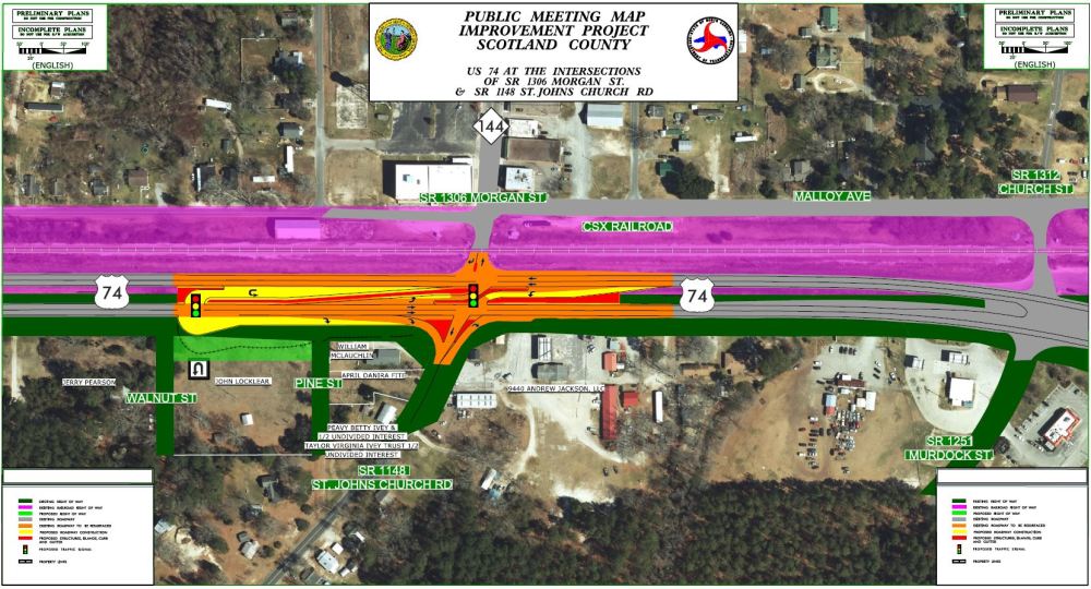
The N.C. Department of Transportation is proposing to make intersection improvements on U.S. 74 (Andrew Jackson Highway) at N. C. 144 (Old Wire Road) in Laurel Hill. Improvements proposed include construction of a reduced conflict intersection and u-turn locations on U.S. 74.
Public Meeting
September 29, 2022
5 - 7 p.m. (staff available at 4 p.m.)
Multitudes Church
8901 Malloy Ave
Laurel Hill
Reduced Conflict Intersections
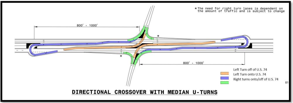
Corridors with growing traffic volumes and high crash rates are good candidates for a reduced-conflict intersection (RCI). A reduced conflict intersection – sometimes referred to as a superstreet, a synchronized street or a median U-turn is a general term used to describe several types of designs that can be used to improve safety and traffic flow on a highway.
A traditional four-way intersection has many potential conflict points. Because drivers can go in any direction from all four approaches, the likelihood of a crash is increased. There are variations to the designs, but they all function the same by cutting more than half of the potential locations, or conflict points, where drivers and pedestrians can collide. The most common type of reduced conflict intersection design eliminates left turns from side roads onto busy main roads.
Raised medians direct traffic from the side road into turning right. When there is a safe opening in traffic, drivers enter the flow of traffic on the main route.
To go the other direction, or cross the highway, they pull into a dedicated lane – a short distance away – and make a U-turn. There might be a traffic signal at this location.
Left Turns from U.S. 74 onto N.C. 144 will be permitted using a dedicated turn lane and medians.
Project Funding:
Activity | Estimated Amount* |
Right of Way Acquisition | $ 150,000 |
Construction Costs | $ 1,850,000 |
Total Cost | $ 2,000,000 |
Most current verified cost estimates - Subject to change
Project Timeline:
Milestone | Date |
| Public Meeting | September 2022 |
Right of Way Acquisition | December 2022 |
Construction Begins | April 2023 |
Future dates subject to change
Comments
NCDOT accepts comments throughout all planning, design and construction phases of project development.
All comments will be taken into consideration, and carry equal weight, regardless of submittal method.
Comments for consideration during the current phase of project development were submitted by October 16, 2022.
Project Contact Information:
Michael Ricketts
NCDOT Highway Division 8
Division Design Construction Engineer
121 DOT Drive
Carthage, NC 28327
RESOURCES FOR PROPERTY OWNERS
Although the N.C. Department of Transportation works to minimize the number of homes and businesses displaced by a road project, it is inevitable, in many cases, that a certain amount of private property is needed. The following information explains right-of-way acquisition and answers questions about the process.
Right-of-Way Acquisition Process Brochure Folleto del Proceso de Adquisición de Bienes Raíces
Right-of-Way Frequently Asked Questions
Right of way Acquisition Process Videos
Title VI Feedback
To ensure we’re hearing from a broad set of voices, would you be willing to share (completely anonymously) some information about yourself?
If so, please click here https://publicinput.com/NCDOT-Title-VI


