 R-5757 - N.C. 305 - Northampton County
R-5757 - N.C. 305 - Northampton County
Improvements to N.C. 305 From The Seaboard Town Limits
To The Hertford County Line in Northampton County
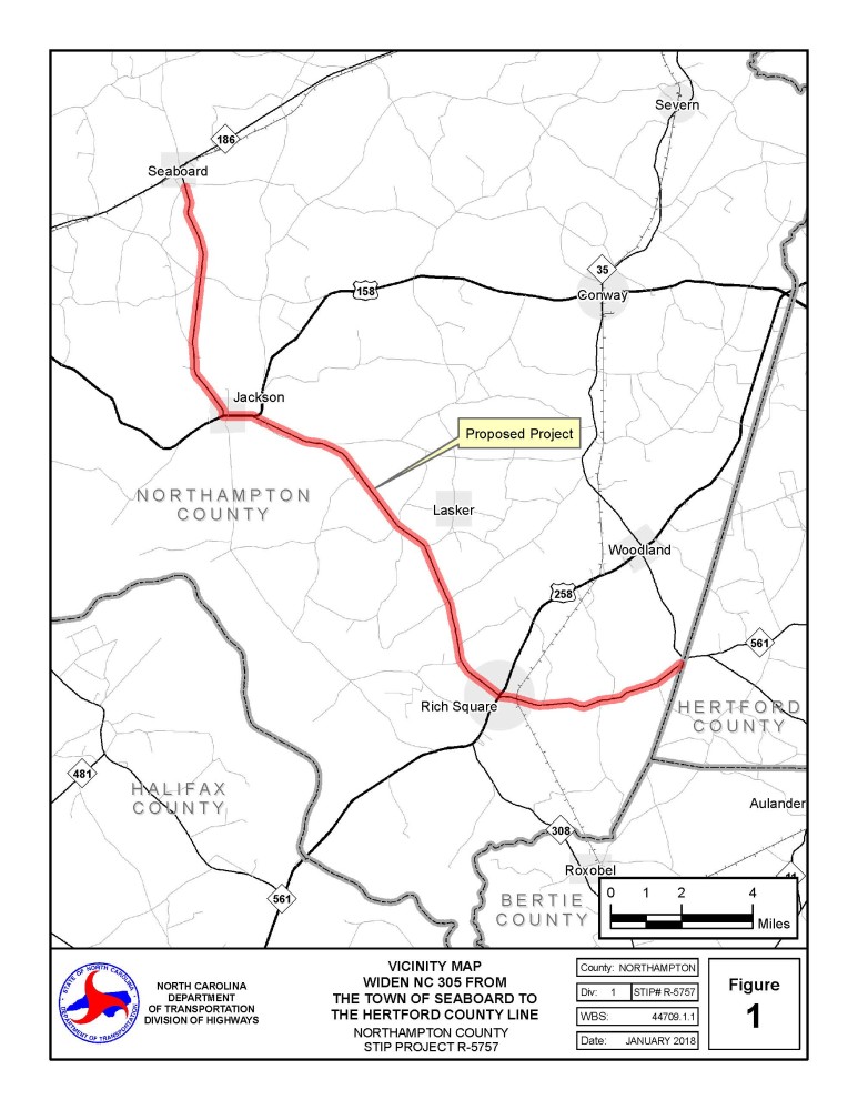
Vicinity Map:
Project Overview:
The N.C. Department of Transportation proposes improvements to N.C. 305 in Northampton County from the Seaboard Town Limits to the Hertford County line, a distance of approximately 24 miles. The project will not add additional through lanes but will provide consistent 11-foot travel lanes on the existing two-lane road, along with wider shoulders. The purpose of the project is to upgrade the roadway, with the improvements aiding in the safety and operation of traffic along N.C. 305.
The project includes improvements to several intersections, minor curve realignments, adding a center turn lane in the vicinity of Central Elementary School, adding guardrail in some locations, and the replacement of all culverts, some cross pipes, and two bridges. The existing pavement on N.C. 305 in Jackson will have at least part of its surface removed (referred to as “milling”) and new pavement added, while the remaining roadway within the project limits will be re-paved. The Flythe Street connection to N.C. 305 in Jackson will be removed and the adjacent sidewalk replaced. Curb and gutter and sidewalk replacement is proposed in the Town of Rich Square east of Short Street and at the northeast corner of the N. Main Street intersection.
Two bridges over the Urahaw Swamp, located approximately two miles north of Rich Square, will be replaced in their existing locations. During construction of the new bridges, traffic will be maintained along N.C. 305 using one lane for two-way traffic, with traffic controlled by a temporary signal.
Project Highlights:
- Will upgrade N.C. 305 in Northampton County from Seaboard Town Limits to Hertford County line
- Provides consistent 11-foot travel lanes on the existing two-lane road, and 2-foot paved shoulders within an overall 4 to 8-foot shoulder width
- Improves five intersections, provides minor curve realignments, and replaces all culverts and some cross pipes
- Replaces two bridges over Urahaw Swamp
Planned Intersection Improvement Locations
- Jackson By-Pass Road (S.R. 1311)
- Pleasant Grove Road (S.R. 1314)
- U.S. 158
- Dusty Hill Road (S.R. 1501)
- Lasker Road (S.R. 1503)
Project History:
The planning phase for this project began in 2017, and a public meeting was held in March 2018 to present information about the proposed improvements to the community. Comments provided by the public, local leaders, and resource agencies were used to refine the designs to minimize impacts. In 2019, planning for the project was temporarily put on hold due to budget constraints; however, work resumed in early 2021.
Public Input:
Comments from the public were submitted to NCDOT by December 15.
Project Maps:
Bold numbers on overview maps (Maps 1,2 and 3) correspond to individual section maps.
Once opened, clicking on the Bold number will open the individual map
Map 1 N.C. 305 from Hertford County line to 1 mile past Harrington Road (10 maps in one file)
Map 2 N.C. 305 from 1 mile past Harrington Road to half mile on Jefferson Street (U.S. 158) (15 maps in one file)
Map 3 N.C. 305 from half mile onto Jefferson Street to Harris Street (15 maps in one file)
If you prefer not to open the entire map group above, you can select individual maps by location using the table below
Individual maps by location can be viewed by clicking on the Map number to the right of the name
| Rich Square | |
West of Eagletown Road | Map 4 Map 5 |
Lovers Lane Road | Map 6 |
Main Street | Map 7 Map 8 Map 9 |
Harrington Road | Map 10 |
Pinners Church Road | Map 11 Map 12 |
Griffin Road | |
Lasker Road | |
Braswell Road | |
| Jackson | |
Dusty Hill Road | |
John Darden Road | |
N.C. 305 at U.S. 158 | |
North Church Street | |
Landfill Road | |
Pleasant Grove Road | |
Jackson Bypass Road | |
| Seaboard | |
Elm Street |
Project Funding:
R-5757 is listed in the State Transportation Improvement Program and funded for $ 52.15 million.
Activity | Estimated Amount* |
Property Acquisition | $ 1,525,000 |
| Utilities Relocation | $ 4,122,000 |
Construction Costs | $ 54,700,000 |
Total Cost | $ 60,347,000 |
* As shown in the currently adopted State Transportation Improvement Program - Subject to change
Project Timeline:
Milestone | Date* |
Public Outreach | November 2021 |
| Newsletter Update | November 2021 |
| Signed Environmental Document | March 2022 |
Right of Way | July 2022 |
Construction | August 2028 |
* As shown in the currently adopted State Transporation Improvement Program - Subject to change
Comments
All comments will be taken into consideration, and carry equal weight, regardless of submittal method
Project Contact Information:
Justin Smith, PE
NCDOT Highway Division 1
Project Manager
113 Airport Drive, Suite 100
Edenton, NC 27932
Project Consultant Information:
Brandon Johnson PE
Summit Engineering
Project Manager
100 E. Six Forks Road, Suite 300
Raleigh, NC 27609
Project Email Address: NC305-Northampton@PublicInput.com
Title VI Feedback
To ensure we’re hearing from a broad set of voices, would you be willing to share (completely anonymously) some information about yourself?
If so, please click here: https://publicinput.com/ncdot-title-vi-form
RESOURCES FOR PROPERTY OWNERS
Although the N.C. Department of Transportation works to minimize the number of homes and businesses displaced by a road project, it is inevitable, in many cases, that a certain amount of private property is needed. The following information explains right of way acquisition and answers questions about the process.
Right-of-Way Brochure Single Page Layout Folleto del Proceso de Adquisición de Bienes Raíces
Right-of-Way Frequently Asked Questions
Right of way Acquisition Process Videos
Page last updated: June 3, 2026
ADA Compliance Checked