R-2522: U.S. 21 (N. Main Street) Improvements
R-2522: U.S. 21 (N. Main Street) Improvements
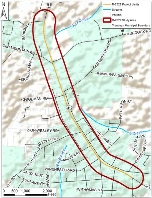
The N.C. Department of Transportation is proposing to widen approximately 1.7 miles of U.S. 21 (N. Main Street) from Cedar Lane (S.R. 2005) in the town of Troutman to Barium Lane (S.R. 1336) in Barium Springs, Iredell County.
This project will be reprioritized for funding in the next State Transportation Improvement Program. A schedule for right of way, utilities and/or construction has not been finalized at this time. However, preliminary engineering activities (design, planning, studies) needed for project development are underway.
Vicinity Map:
Purpose and Need:
The purpose of the project is to improve safety along U.S. 21 (N. Main Street) while providing additional vehicular capacity and enhancing bicycle and pedestrian accommodations. The proposed project will address the mobility needs of current and future traffic conditions without compromising the character of Troutman.
Project Overview:
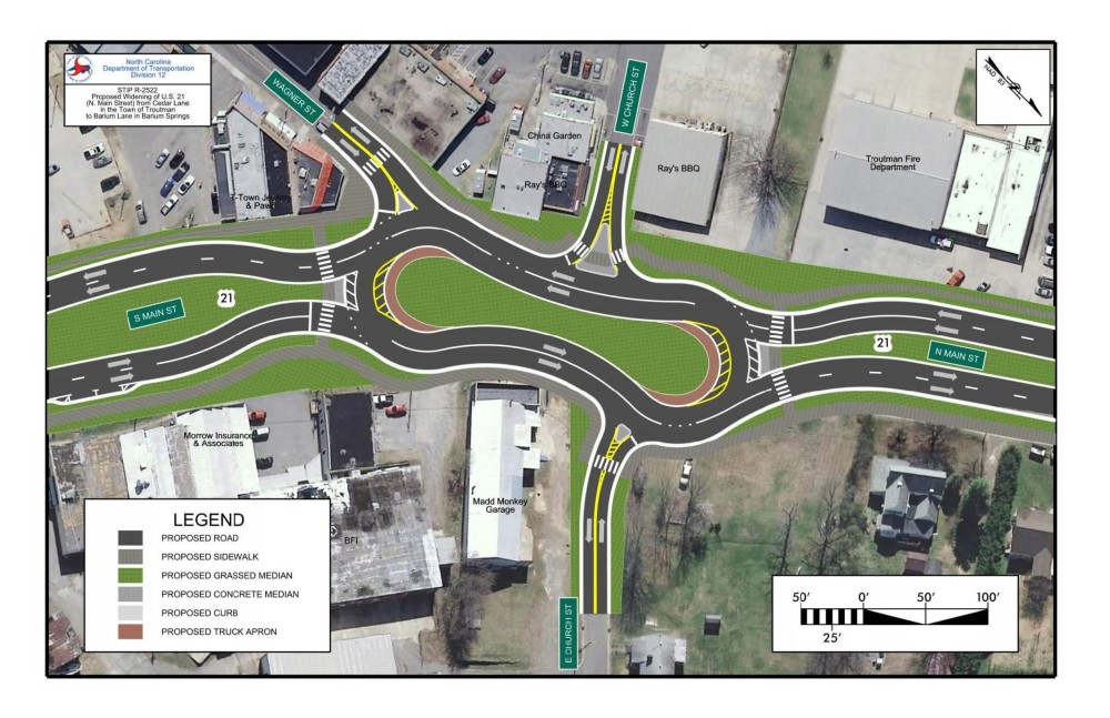
The proposed Build Alternative would create four travel lanes along the existing corridor by converting the existing roadway to two southbound lanes, converting the existing Eastway Drive between Winecoff Street and Old Murdoch Road to two northbound lanes, and constructing two new northbound lanes from Old Murdoch Road to Barium Lane. The project also proposes to reconfigure the existing U.S. 21 intersections with Wagner Street and Church Street by constructing a modified roundabout facility—referred to as a “peanut roundabout”—because of its shape.
Public Involvement
Public Meetings
A public meeting was held on May 2, 2019 at Troutman Town Hall (400 N. Eastway Dr, Troutman) to present project maps and receive public input.
2019 Public Meeting Maps
Summary of Comments Received, Responses and all documents presented May 2, 2019
Project History
R-2522 was initially investigated as part of the Town of Troutman’s US 21 / NC 115 Corridor Study which was approved by the Town in July 2017. It was the intent of that study to be used as a starting point and guide for R-2522 as it investigated widening U.S. 21 / N.C. 115 to a multi-lane section through Troutman.
In November 2016, NCDOT began the environmental planning studies for R-2522. Using the foundation of the U.S. 21 / N.C. 115 Corridor Study as a starting point, three alternatives have been developed for evaluation as part of the ongoing studies.
Alternative 1 (concept developed for U.S. 21/N.C. 115 Corridor Study)
Alternative 1 is the concept developed as part of the U.S. 21 / N.C. 115 Corridor Study approved by the Town of Troutman in July 2017. This corridor study extended from Westmoreland Road, east of I-77 and extended to Barium Lane in Barium Springs. It also proposed a realignment of Wagner Street near downtown Troutman. Alternative 1 utilizes N. Eastway Drive as the northbound lanes of U.S. 21 and provides a multi-use path in the median.
Alternative 2 (concept developed for U.S. 21/N.C. 115 Corridor Study but modified to match project limits of R-2522)
Alternative 2 is a modification of Alternative 1 to more closely match the project limits of R-2522 as described in the State Transportation Improvement Program, Cedar Lane in Troutman to Barium Lane in Barium Springs. Similar to Alternative 1, Alternative 2 utilizes N. Eastway Drive as the northbound lanes of U.S. 21 and provides a multi-use path in the median.
Alternative 3 (Proposed Alternative)
Alternative 3 also utilizes the existing N. Eastway Drive as the northbound lanes but provides a multi-use path on the east side of the roadway instead of the median as proposed in Alternatives 1 & 2. Alternative 3 also includes improvements to the U.S. 21 / Wagner Street / W. Church Street / E. Church Street intersection by replacing the traditional type of intersections with a Peanut Roundabout which will allow traffic to travel through this intersection safely and more efficiently.
Project Funding
This project is listed as Project No. R-2522 in the N.C. Department of Transportation's State Transportation Improvement Program (STIP) and is funded for $34.8 million.
| Estimated Amount* |
Total Cost | $ 34,800,000 |
* Estimated costs are subject to change
Project Timeline
Milestone | Date* |
Public Meeting | May 2, 2019 |
Preliminary Design | TBD |
Final Environmental Document | Summer 2028 |
Right-of-Way Acquisition | TBD |
Construction | TBD |
* Future dates are preliminary and subject to change
Project Comments
The public comment period closed on May 16, 2019 for information presented at the May 2, 2019 public meeting.
NCDOT takes comment throughout the project development process.
All comments will be taken into consideration as the project progresses.
Project Contact Information:
Bryan Sowell, PE
NCDOT Division 12 Project Manager
P.O. Box 47
Shelby, NC 2815
bksowell@ncdot.gov
(980) 552-4221
RESOURCES FOR PROPERTY OWNERS
Although the N.C. Department of Transportation works to minimize the number of homes and businesses displaced by a road project, it is inevitable, in many cases, that a certain amount of private property is needed. The following information explains right of way acquisition and answers questions about the process.
Right-of-Way Brochure Single Page Layout Folleto del Proceso de Adquisición de Bienes Raíces
Right-of-Way Frequently Asked Questions
Right of way Acquisition Process Videos
The N.C. Department of Transportation is proposing to widen approximately 1.7 miles of U.S. 21 (N. Main Street) from Cedar Lane (S.R. 2005) in the town of Troutman to Barium Lane (S.R. 1336) in Barium Springs, Iredell County.
This project will be reprioritized for funding in the next State Transportation Improvement Program. A schedule for right of way, utilities and/or construction has not been finalized at this time. However, preliminary engineering activities (design, planning, studies) needed for project development are underway.
Vicinity Map:
Purpose and Need:
The purpose of the project is to improve safety along U.S. 21 (N. Main Street) while providing additional vehicular capacity and enhancing bicycle and pedestrian accommodations. The proposed project will address the mobility needs of current and future traffic conditions without compromising the character of Troutman.


