 U-5706 Eastern Rockingham Corridor Study
U-5706 Eastern Rockingham Corridor Study
New Location Roadway between U.S. 74 Business and Richmond Road in Eastern Rockingham
PROJECT OVERVIEW
The N.C. Department of Transportation proposes the creation of a new location road from U.S. 74 Business to Richmond Road (S.R. 1423) in eastern Rockingham. The project would begin with improvements to Clemmer Road, and continue northward as a new road, ending near the intersection of Richmond Road and Roberdel Road, a total distance of about four miles. The purpose of the project is to provide direct connectivity between commercial areas along U.S. 74 Business and residential areas northeast of central Rockingham and reduce conflicts between through traffic and local traffic on Long Drive.
Currently, large volumes of cars and trucks travel between businesses along East Broad Avenue (U.S. 74 Business) and the residential areas northeast of downtown Rockingham. Much of this through-traffic uses Long Drive, which, along with Richmond Road, is the only direct route between these two areas. Long Drive and Richmond Road were not designed to accommodate this level of through-traffic. As a result, safety has diminished, and traffic congestion has increased on these streets. With planners predicting even higher volumes in the future, conditions on these streets are expected to worsen. The new road would provide a more direct route between East Broad Avenue and residential areas to the north, allowing Long Drive to return to its intended function as a local street.
PROJECT HISTORY
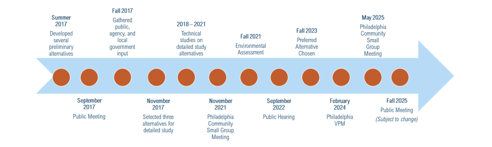
The project began in 2015. Six alternatives were studied including a no build alternative. These preliminary project alternatives were presented to the public, local government and agency representatives. Comments were gathered and additional studies were conducted. A preferred alternative (Alternative 5) was selected in 2023, and further comments were sought from the community and local government. The Preferred Alternative is subject to change.
For more details about the alternatives studied, please review the Environmental Assessment document.
STATE ENVIROMENTAL ASSESSMENT
Due to the size, this document is being posted in 3 parts:
PREFERRED ALTERNATIVE
Alternative 5 was selected as the preferred alternative in March 2023, following the September 15, 2022 corridor public hearing. The selection was made based on public input, environmental and right-of-way considerations. This alternative had the most favorable support from the community. It will have the least impacts on streams and will require the least number of residential and business relocations. In addition, this alternative will have a lower cost than the other project alternatives.
The selected corridor will provide a more direct route between East Broad Avenue and the residential areas to the north, allowing Long Drive to return to its intended function as a local street. Alternative 5 will provide a direct route for through traffic from the commercial areas along U.S. 74 Business to residential areas in northeast Rockingham. It will include a combination of existing roadway segments and new location segments. Alternative 5 extends from U.S. 74 Business to the intersection of Old Aberdeen Road and Richmond Road. It follows existing Clemmer Road from U.S. 74 Business to County Home Road, then runs on new location, crossing Washington Street east of Mount Olive Church Road and US 1 near the existing Mount Olive Church Road intersection. North of US 1, Alternative 5 continues on new location to Old Aberdeen Road. The alternative then follows Old Aberdeen Road to Richmond Road.
Alternative 5 will consist of a three-lane road with five-foot sidewalks on each side from U.S. 74 Business to County Home Road (S.R. 1624), a two-lane road from County Home Road to Mount Olive Road (S.R. 1645), and a three-lane road with five-foot sidewalks on each side from Mount Olive Road to Richmond Road (S.R. 1423).
At a recent community meeting in the Philadelphia community, attendees suggested exploring roundabouts as part of the project design. In response to public comments, the team is now studying the potential addition of roundabouts at the intersections of County Home Road and East Washington Street. Updates on this study will be shared at a public meeting before the end of 2025.
The maps below provide you with a detailed view of the Preferred Alternative and the intersections that are being considered for potential roundabouts.
Map 1- Clemmer Road area from US 74 to north of County Home Road (SR 1624)
Map 2- New location roadway section area near Falling Creek
PUBLIC MEETING
A summary of the September 15th, 2022 Corridor Public Meeting and comments received during the comment period can be reviewed using the following link:
U-5706 Post Hearing Meeting Summary
The next public meeting will be held before the end of 2025 to share updated plans incorporating the proposed roundabouts.
PROJECT FUNDING
| PREFERRED ALTERNATIVE | |
|---|---|
Right of Way Acquisition | $18,200,000 |
Utility Relocation | $2,700,000 |
Construction | $64,300,000 |
Total Cost* | $85,200,000 |
* Costs are preliminary and subject to change
PROJECT TIMELINE
SCHEDULE |
|
|---|---|
Design Public Hearing | Late 2025 |
Right of Way Acquisition | Winter 2026 |
Construction | Fall 2030 |
* Dates are subject to change
PROJECT COMMENTS
NCDOT accepts comments throughout all phases of project development.
The public is encouraged to leave comments using this website, email, or phone number:
Email: U5706@PublicInput.com
Phone Number: 512-580-8850 enter project code 3999
TITLE VI FEEDBACK
To ensure we’re hearing from a broad set of voices, would you be willing to share (completely anonymously) some information about yourself?
If so, please click here: https://publicinput.com/NCDOT-Title-VI
PROJECT CONTACT
Mark Johnston
Division Project Team Lead
Division of Highways, Division 8
121 DOT Drive
Carthage, NC 28327
U5706@publicinput.com
512-580-8850 code 3999
PROJECT CONTACT
Brian Eason, PE
H.W. Lochner, Inc.
Consultant Project Manager
2840 Plaza Place, Suite 202
Raleigh, NC 27612
U5706@publicinput.com
512-580-8850 code 3999
RESOURCES FOR PROPERTY OWNERS
Although the N.C. Department of Transportation works to minimize the number of homes and businesses displaced by a road project, it is inevitable, in many cases, that a certain amount of private property is needed. The following information explains right of way acquisition and answers questions about the process.
Right-of-Way Brochure Single Page Layout Folleto del Proceso de Adquisición de Bienes Raíces
Right-of-Way Frequently Asked Questions
Right of way Acquisition Process Videos