 HE-0006: Chatham-TIP-Road-Improvements
HE-0006: Chatham-TIP-Road-Improvements
The N.C. Department of Transportation is proposing roadway network improvements in the area of a large economic development site in southeastern Chatham County known as Triangle Innovation Point.
 Responses to questions received during comment period
The Wilmington District, United States Army Corps of Engineers, has issued a Public Notice:
https://www.saw.usace.army.mil/Missions/Regulatory-Permit-Program/Public-Notices/
Issue Date: November 21, 2022
Expiration Date: 5:00 p.m. January 5, 2023
Point of Contact: David Bailey
Email: David.E.Bailey2@usace.army.mil
Project Description:
VinFast would be responsible for the design, construction, and mitigation requirements for the Project Blue portion of the Project. The North Carolina Department of Transportation (NCDOT) would be responsible for the design, construction, and mitigation requirements for the State Transportation Improvement Project (STIP) # HE-0006) road improvements portion of the Project. Additionally, VinFast would be entering into developer agreements with the City of Sanford, Dominion Energy, and Duke Energy Progress to design, construct, and mitigate for the necessary offsite utilities connecting to the Project Blue site.
Interactive Study Area Map
This map shows the vicinity of the project and represents the area in which studies are being conducted and improvements considered.
(Triangle Innovation Point Boundaries are shown in Blue)
Based on Chatham County’s vision for the Moncure Megasite (also known as Triangle Innovation Point), a 2,150-acre group of parcels under one ownership being promoted for industrial development, roadway improvements are needed in this area.
Chatham County’s Future Land Use and Conservation Plan indicates the area is an “Employment Center” and is targeted for future job-generating uses.
Development of the Triangle Innovation Point East site will support the County’s primary economic development goal to Diversify the tax base and generate more high quality, in-county jobs to reduce dependence on residential property taxes, create economic opportunity and reduce out-commuting. The project will support goals outlined in Chatham County’s Future Land Use and Conservation Plan.
Public Meeting Information
________________________________________________
Video of August 18, 2022 Virtual Public Meeting
_______________________________________________
A handout containing information presented on the website and at public meetings
can be viewed or downloaded by clicking on the picture below
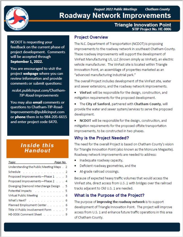
The Triangle Innovation Point Roadway Network Improvements will be completed in two phases.
Phase 1 (Public Meeting Map for Phase 1)
Anticipated improvements include:
modifying the U.S. 1 interchange with Old U.S. 1 (Exit 84)
adding a new U.S. 1 interchange with New Elam Church Road
realigning New Elam Church Road between U.S. 1 and Old U.S. 1
upgrading this section of New Elam Church Road to a multi-lane facility
constructing interchange access from realigned New Elam Church Road to Old U.S. 1
spanning the railroad right of way with the interchange bridge
improving the Christian Chapel Church Road intersection with N.C. 42
Phase 2 (Public Meeting Map for Phase 2)
Anticipated improvements include:
- new interchange at Old US 1,
- new Pea Ridge Road
- new DDI at Pea Ridge and US 1.
Project Funding
Estimates for Right-of-Way, Utilities and Construction are under development at this time and will be posted here as they become available.
|
Project Timeline
Milestone | Phase 1 | Phase 2* |
|---|---|---|
Right-of-Way | Spring 2025 | To Be Determined |
Construction | Summer 2027 | To Be Determined |
Future dates are preliminary and are subject to change
* Phase 2 is expected to proceed following notification that necessary job creation goals, outlined in N.C. General Assembly Session Law 2022-74, have been met.
Project Contact
Jeffrey L Teague, PE
NCDOT Highway Division 8
Division Project Development Engineer
121 DOT Drive
Carthage, NC 28327
Chatham-TIP-Road-Improvements@PublicInput.com
984-205-6615 code 6470
Project Contact
Kristina Miller, PE
RK&K
Senior Project Delivery Lead
8601 Six Forks Road (Forum 1 Ste 700)
Raleigh, NC 27615
Chatham-TIP-Road-Improvements@PublicInput.com
984-205-6615 code 6470
Title VI Feedback
To ensure we’re hearing from a broad set of voices, would you be willing to share (completely anonymously) some information about yourself?
If so, please click here https://publicinput.com/NCDOT-Title-VI-Form
RESOURCES FOR PROPERTY OWNERS
Although the N.C. Department of Transportation works to minimize the number of homes and businesses displaced by a road project, it is inevitable, in many cases, that a certain amount of private property is needed. The following information explains right of way acquisition and answers questions about the process.
Right-of-Way Brochure Single Page Layout Folleto del Proceso de Adquisición de Bienes Raíces
Right-of-Way Frequently Asked Questions
Right of way Acquisition Process Videos
Page last updated: February 24, 2026