 U-5974: N.C. 68 - HighPoint
U-5974: N.C. 68 - HighPoint
U-5974: N.C. 68 - High Point - Project Update
During the public comment period following the October 2020 public meeting, NCDOT received feedback from local residents, business owners, developers, and others. Public input is a fundamental component of effective transportation planning and project development, and NCDOT values all input for this project.
Based on comments received, the project team looked at a potential combination of the two alternatives and developed a new alternative design that serves the projected future traffic demands along N. C. 68 and addresses concerns.
Information on Alternative 3 is presented below.
Click Here to skip directly to Alternative 3 information
 Click Here to view recently posted documents
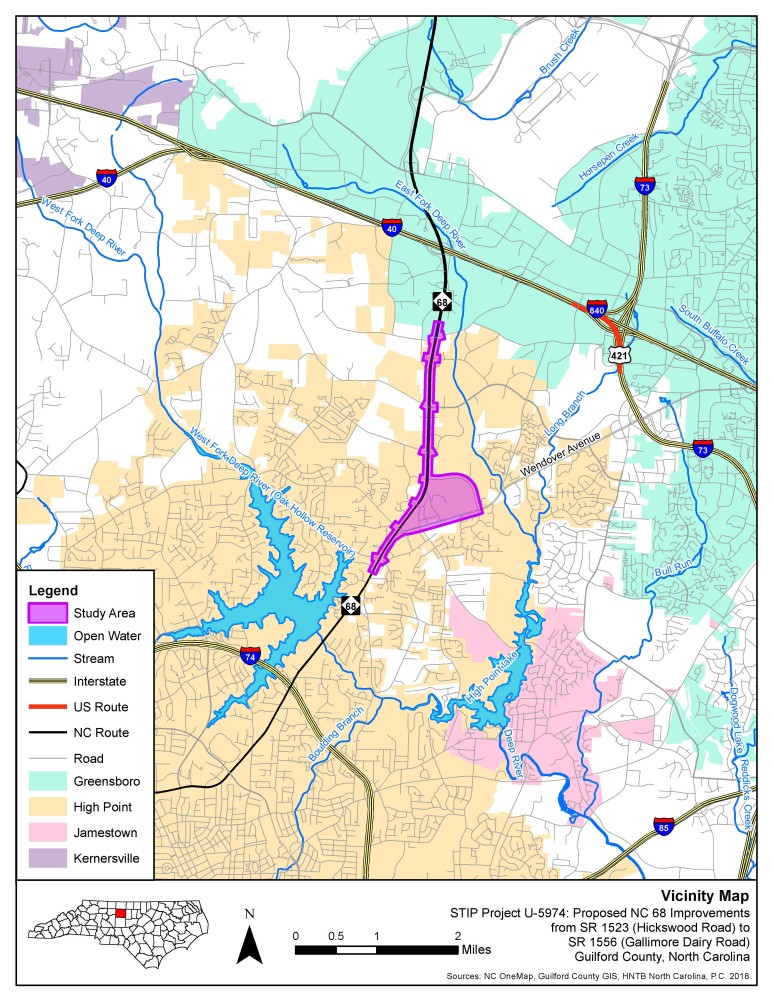
The N.C. Department of Transportation is proposing to improve N.C. 68 (Eastchester Drive) from Hickswood Road (S.R. 1523) to Gallimore Dairy Road (S.R. 1556) in High Point.
The purpose of this project is to address existing and projected congestion and to improve mobility and traffic flow on this critical facility in northern High Point. Proposed improvements would include capacity and non-traditional intersection designs.
Vicinity Map:
Thank you for your interest and input on the N.C. 68 Improvements project.
All comment received during the public comment period, which closed in April, 2022 have been collected and reviewed by NCDOT.
Project History:
The High Point Urban Area Metropolitan Planning Organization (HPMPO) identified the N.C. 68 (Eastchester Drive) corridor between Penny Road and Gallimore Dairy Road as a Boulevard needing improvement in its 2010 Comprehensive Transportation Plan. HPMPO is currently developing the 2020 Comprehensive Transportation Plan. The draft Plan (dated March 17, 2020) recommends congestion/mobility improvements along the N.C. 68 (Eastchester Drive) corridor between I-74/U.S. 311 and Gallimore Dairy Road.
North Carolina General Statute 136-6.2 requires each municipality or Metropolitan Planning Organization (MPO), with the cooperation of NCDOT, to develop a Comprehensive Transportation Plan (CTP) serving present and anticipated travel demand in and around the municipality or MPO. The CTP includes community consensus on future transportation needs required to support anticipated growth and development. It is a multi-modal plan that identifies the future transportation system needs and includes highways, public transportation, rail, and bicycle facilities needed to serve the anticipated travel demand. It strengthens the connections between the area’s transportation plan, adopted local land development plan, and community vision.
The U-5974 project is included in the HPMPO Draft 2045 Metropolitan Transportation Plan (MTP) as a 2035 Horizon Year project. The MTP is the official multi-modal transportation plan that addresses a 25-year planning horizon that is developed, adopted, and updated by the MPO through the metropolitan transportation planning process.
Proposed Highlights
Proposed improvements to N.C. 68 (Eastchester Drive) include adding one additional travel lane in each direction as well as intersection improvements. Two build alternatives were originally studied which included traditional intersection, Continuous Flow Intersection (CFI), and Reduced Conflict Intersection (RCI) designs.
Alternative 1 (6-Lane Widening with Reduced Conflict Intersection (RCI) Design):
Previously presented traffic simulation video of Alternative 1
- An additional lane in each direction of N.C. 68
- A Continuous Flow Intersection (CFI) at N.C. 68 and W. Wendover Avenue/Skeet Club Road
- Conversion of N.C. 68 intersections to Reduced Conflict Intersection (RCI) designs at the following locations: Penny Road (S.R. 1536), Samet Drive, Premier Drive, Willard Dairy Road (S.R. 1836)/Mendenhall Oaks Parkway, Clinard Farms Road (S.R. 1837)/Piedmont Parkway, Regency Drive, and Gallimore Dairy Road.
- The intersection of N.C. 68 and Hickswood Road/Meadowlark Road would remain a conventional intersection.
Alternative 2 (6-Lane Widening with Conventional Intersection Design):
Previously presented traffic simulation video of alternative 2
- An additional lane in each direction of N.C. 68
- A Continuous Flow Intersection (CFI) at N.C. 68 and W. Wendover Avenue/Skeet Club Road
- All other N.C. 68 intersections would remain conventional signals and turn lanes, with additional lane storage added where needed
NEW - Alternative 3 (Hybrid design containing a combination of Reduced Conflict and Conventional Intersections)
- An additional lane in each direction of N.C. 68
- A Continuous Flow Intersection (CFI) at N.C. 68 and W. Wendover Avenue/Skeet Club Road
- Traditional intersections at Premier Drive, Piedmont Parkway / Clinard Farms Road, and Gallimore Dairy Road
- Reduced Conflict Intersections at Penny Road, Samet Drive, Mendenhall Oaks Parkway / Willard Dairy Road, Meeting Way, and Regency Drive.
Alternative 3 - Overview Video
Several informational videos were presented previously. They can be accessed by clicking on the links below.
Project Introduction and Overview Video (Alternatives 1 and 2)
How to read public meeting & hearing maps
Traffic Simulation Video (Alternative 1) | What is a Reduced Conflict Intersection?
Traffic Simulation Video (Alternative 2) | What is a Continuous Flow Intersection?

Reduced Conflict Intersections (NCDOT)
Safe Access is Good for Business (NCDOT)
Safe Access is Good for Business (FHWA)
Economic Effect of Restricted Crossing U-Turn Intersections (Louisiana)
Developing, Using, and Improving Tables Showing the Safest Feasible Intersection Design (NCDOT)
Pedestrian Crossing Movements
Reduced Conflict Intersections
Pedestrian Crossing Movements
Reduced Conflict Intersections
Project Introduction and Overview Video
Project Traffic Analysis and Safety Video
Project Funding: This project is listed as Project No. U-5974 in the STIP and is funded for $69.1 million.
Activity | Estimated Amount* |
Project Development & Design** | $ 1,675,000 |
Right-of-Way | $ 19,333,000 |
Construction Costs | $ 48,100,000 |
Total Cost | $ 69,108,000 |
* Estimated costs are subject to change. **Prior year cost.
Project Timeline:
The project timeline as shown in the STIP follow:
Milestone | Date* |
Public Meeting | Fall 2020 |
Environmental Document | 2024 |
Right-of-Way | 2026 |
Construction | 2028 |
* Future dates are preliminary and subject to change
Project Comments and Questions
NCDOT accepts comments at all times thoughout the planning, design and construction of projects.
You may contact the project team via email or phone if you have questions on the project.
Email the comment or question to NC68-HighPoint@PublicInput.com
Or
Phone Number: (855) 925-2801 Code: 4871
The comment period on the Hybrid Alternative (Alternative 3) closed on April 22, 2022.
Project Contact Information
Brandon Green, PE
NCDOT Structures Management Unit
Project Engineer
1581 Mail Service Center
Raleigh, NC 27699-1581
Paige Hunter, PE
HNTB
Project Consultant
101 South Tryon Street, Suite 3610
Charlotte, NC 28202
RESOURCES FOR PROPERTY OWNERS
Although the N.C. Department of Transportation works to minimize the number of homes and businesses displaced by a road project, it is inevitable, in many cases, that a certain amount of private property is needed. The following information explains right of way acquisition and answers questions about the process.
Right-of-Way Brochure Single Page Layout Folleto del Proceso de Adquisición de Bienes Raíces
Right-of-Way Frequently Asked Questions
Right of way Acquisition Process Videos