 U-5969: U.S. 501/Madison - Roxboro
U-5969: U.S. 501/Madison - Roxboro
NCDOT is proposing to convert U.S. 501 (Madison Boulevard) from a 5-lane undivided roadway to a 4-lane median divided roadway from south of U.S. 158 to North Main Street.
New: Responses to comments received during the 2019 comment period can be viewed here: 
This project will be reprioritized for funding in the next State Transportation Improvement Program. A schedule for right of way, utilities and/or construction has not been finalized at this time. However, preliminary engineering activities (design, planning, studies) needed for project development are underway.
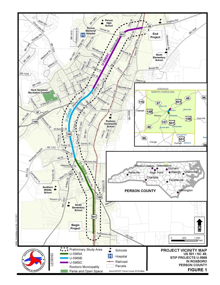
Vicinity Map:
 Features Maps:
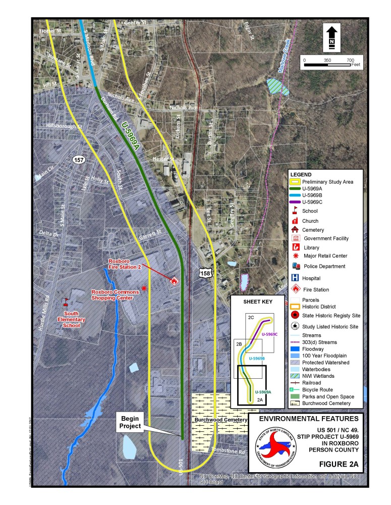
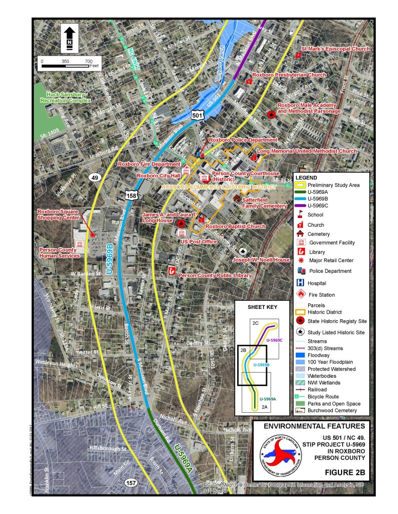
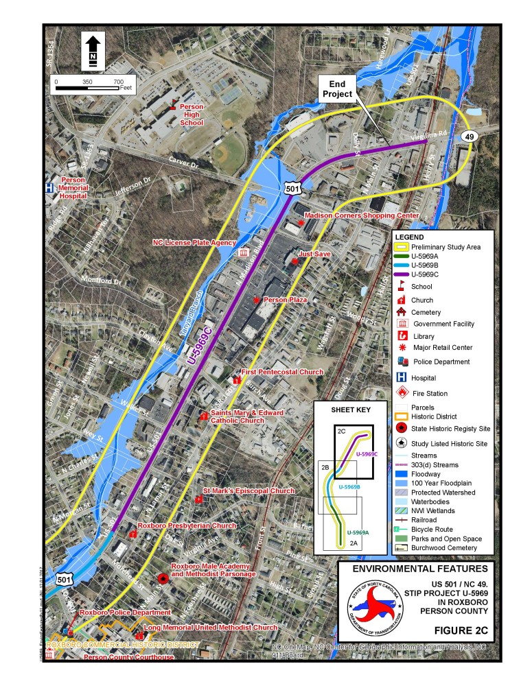
Section A

Section B

Section C

Project Overview and Purpose
At the request of the Kerr-Tar Rural Planning Organization (RPO), the N.C. Department of Transportation is proposing to convert U.S. 501 (Madison Boulevard) from a 5-lane undivided roadway to a 4-lane median-divided roadway from south of U.S. 158 to North Main Street. The proposed project is approximately three miles in length and is included in the 2018-2027 North Carolina State Transportation Improvement Program (STIP) as project number U-5969.
Land uses along Madison Boulevard are primarily commercial with a few residential and industrial areas. Madison Boulevard serves as a vital corridor in Person County and for the City of Roxboro. Downtown historic Roxboro is located adjacent to the project corridor. The corridor is a part of a larger initiative to widen US 501 to a 4-lane roadway from the Virginia state line to NC 49. Converting Madison Boulevard to 4 lanes will allow for a continuous cross section throughout the entirety of US 501.
The proposed project will improve safety in the area by limiting access at driveways and lower volume intersections and will also enhance mobility and bicycle and pedestrian accommodations along the project corridor. Thirteen Intersections along US 501 were identified in the Person County and Roxboro Comprehensive Transportation Plan (CTP) as high crash locations. According to the traffic forecast completed in November 2017, the current Annual Average Daily Traffic (AADT) along the corridor ranges from 8,500 vehicles per day (vpd) to 28,600 vpd. The traffic volume is projected to increase to 10,600 vpd to 38,100 vpd in 2040. Limiting access along Madison Boulevard will help reduce the potential for crashes and will make the roadway safer not only for motorists, but also for bicyclists and pedestrians.
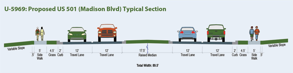
Proposed Typical Roadway Section
Traffic Safety Analysis
A traffic safety analysis of the corridor has been completed. This analysis evaluated 25 intersections along the corridor and used historical crash data for the most recent five years (2013-2017).
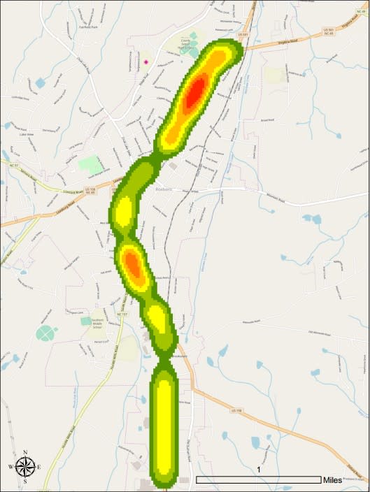
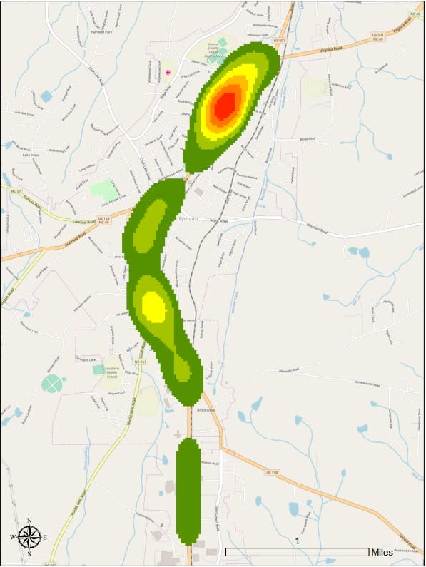
A total of 852 crashes occurred during the study period (2013-2017), including 179 fatal/injury crashes resulting in 1 fatality. Additionally, five pedestrian crashes and one bicycle crash occurred during the five-year period. It should be noted that 19 of the 852 crashes involved an animal. Figure 1 provides a heat map of all observed traffic crash locations specific to the study corridor. Figure 2 provides a heat map of the fatal and injury (FI) crashes.
The crash rate of the corridor is 604.44 crashes per 100 million vehicle miles travelled (2015-2017), compared to the statewide crash rate of 247.78 crashes per 100 million vehicle miles travelled for U.S. Urban Routes. Studies show that raised medians reduce crashes by over 40 percent in urban areas and over 60 percent in rural areas. Decreasing the number of traffic collisions will also help decrease traffic congestion.
The safety analysis also included the predicted and expected crashes in 2040. If no improvements are made within the corridor, the annual predicted crashes are expected to increase by 27%.
Due to projected increase in crashes in the design year, several safety countermeasures have been identified to be implemented within the corridor to increase safety.
The proposed safety countermeasures, such as medians and improvements to side street skews, have been proven in prior research to improve traffic safety. Implementing these treatments will help reduce the majority of angle and rear-end collisions that occur in the study corridor. Installation of a raised concrete median would reduce the risk of traffic conflicts and as well as angle and turn crashes. Improving the skew angle at the approaches of certain signalized intersections will improve the driver’s reaction time and reduce the risk of rear-end collisions. Installation of a traffic signal at certain unsignalized intersections would relieve inadequate gap time and thus potentially reduce the number of angle and turn collisions. Upgrading the existing traffic signals will reduce the risk for rear-end, angle and turn collisions. Given the amount of visual clutter present within the study area, improving the conspicuity of traffic signals can help improve compliance with the intended message of these devices, leading to potential increased safety performance.
Heat Map Showing All Crashes
Heat Map Showing Fatal Injury Crashes
Project History
The project was recommended in the Person County and Roxboro Comprehensive Transportation Plan as project PER0002-H in 2011.
The project was included in the Madison Boulevard Corridor Plan by Kerr-Tar RPO in May of 2016.
The 2018-2027 State Transportation Improvement Program (STIP) includes the project as STIP number U-5969.
NCDOT Division 5 began project development, environmental, and engineering studies for this project in November 2017.
Public Involvement
NCDOT has been coordinating with the City of Roxboro throughout the project. A postcard was sent in May 2018 to property owners located within the project study area, to introduce the project. Project information and updates will be posted to this website. Other outreach may include newsletters, local official briefings, small group presentations, and public meetings.
Public Meeting
A public meeting was held on August 29, 2019 at the Person County Office Building Auditorium (304 S. Morgan Street, Roxboro)
Maps displayed at the August 29, 2019 meeting:
Map 1: U.S. 501 from South of U.S. 158 to North Main Street
Map 2: U.S. 501 from South of U.S. 158 to North Main Street
Public involvement is an integral part of the planning process.
NCDOT encourages citizen involvement on transportation projects, and will consider your suggestions and address your concerns. Responses to comments received during the 2019 comment period can be viewed here:
Questions or comments may be submitted at any time by calling the project manager listed below or emailing
Project Cost and Schedule
This project is listed as Project U-5969 in the N.C. Department of Transportation’s State Transportation Improvement Program and is funded for $32.6 million.
| Estimated Amount* | Estimated Amount* | Estimated Amount* |
U-5969A | U-5969B | U-5969C | |
Property Acquisition and Utilities | $ 8,409,747 | $ 7,560,447 | $ 7,571,447 |
Construction Costs | $ 6,400,000 | $ 13,800,000 | $ 9,800,000 |
Total Cost | $ 14,809,747 | $21,360,447 | $17,371,447 |
* Estimated costs are subject to change.
Milestone | Date* | Date* | Date* |
U-5969A | U-5969B | U-5969C | |
Public Meeting | August 2019 | August 2019 | August 2019 |
Environmental Document (Environmental Assessment) | Spring 2022 | Spring 2022 | Spring 2022 |
Right of Way Acquisition | August 2026 | July 2028 | July 2028 |
Construction | Summer 2028 | Summer 2030 | Summer 2030 |
* Future dates are preliminary and subject to change
Next Steps
Preliminary designs for the overall corridor will be advanced and evaluated.
A Combined State Environmental Assessment / Finding of No Significant Impact (SEA/FONSI) is expected to be completed in 2021, followed by a public meeting.
PROJECT CONTACT INFORMATION
John Braxton
NCDOT Project Manager
1020 Birch Ridge Drive
Raleigh, NC 27610
919-707-6219
RESOURCES FOR PROPERTY OWNERS
Although the N.C. Department of Transportation works to minimize the number of homes and businesses displaced by a road project, it is inevitable, in many cases, that a certain amount of private property is needed. The following information explains right of way acquisition and answers questions about the process.
Right-of-Way Brochure Single Page Layout Folleto del Proceso de Adquisición de Bienes Raíces
Right-of-Way Frequently Asked Questions
Right of way Acquisition Process Videos